IMAGES TAKEN NEAR TO
Naildown Close, HYTHE, CT21 5TA
Introduction
This page details the photographs taken nearby to Naildown Close, CT21 5TA by members of the Geograph project.
The Geograph project started in 2005 with the aim of publishing, organising and preserving representative images for every square kilometre of Great Britain, Ireland and the Isle of Man.

There are currently over 7.5m images from over14,400 individuals and you can help contribute to the project by visiting https://www.geograph.org.uk
Image Map
Images are licensed for reuse under creativecommons.org/licenses/by-sa/2.0
Notes
- Clicking on the map will re-center to the selected point.
- The higher the marker number, the further away the image location is from the centre of the postcode.
Image Listing (75 Images Found)
Images are licensed for reuse under creativecommons.org/licenses/by-sa/2.0
Image
Details
Distance
1
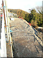
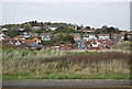
Vacant site
Photographed from Naildown Close, planning permission has been approved, with conditions, by Folkestone and Hythe District Council under application number 20/0511/FH for “land at the junction of Naildown Road and Naildown Close, Hythe for construction of 2 new detached dwellings”.
Image: © John Baker
Taken: 21 Nov 2021
0.02 miles
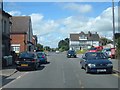
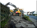
4
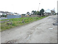
Former site of Cautley House, 95, Seabrook Road
Viewed from Cliff Road, planning permission has been approved, with conditions, by Folkestone and Hythe District Council under application number Y18/1305/FH for the “erection of a residential development comprising of 14 residential units, associated undercroft parking, landscaping and ground works following demolition of the existing building”.
This was Image during its demolition.
Note the state of Cliff Road; not a surface for fast driving.
Image: © John Baker
Taken: 16 Feb 2022
0.08 miles
7
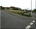
44, Naildown Road
Planning permission has been approved, with conditions, by Folkestone and Hythe District Council under application number 22/0560/FH for the “demolition of existing dwelling. The erection of an apartment block comprising of four 2-bed apartments with underground parking and the erection of two 3-bed new detached dwellings on southern part of the plot”.
Number 44 lies to the right of the furthest lamppost.
Image: © John Baker
Taken: 16 Oct 2022
0.08 miles
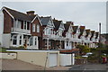
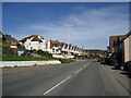
8
Hythe, Seabrook, Seabrook Road (A259)
Image: © Helmut Zozmann
Taken: 5 Jul 2008
0.08 miles
9
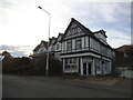
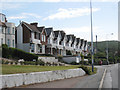
Cautley House, 93, Seabrook Road
According to Shepway District’s planning applications for this property, it has been known in the past as St Frederick’s Hotel and the Centre for Spiritual Healing and according to the Folkestone and District Local History Society it was known as the Sea View Hotel in the early 20th century. http://www.folkestonehistory.org/index.php?page=seabrook It has an air of neglect.
Thanks to John Baker for the information http://www.geograph.org.uk/photo/4301610
Image: © David Howard
Taken: 10 Apr 2016
0.08 miles
10
Cautley House, 95 Seabrook Road
Planning permission has been approved, with conditions, by Folkestone and Hythe District Council under application number Y18/1305/FH for the “erection of a residential development comprising of 14 residential units, associated undercroft parking, landscaping and ground works following demolition of the existing building”.
This was Image in December 2014.
Image: © John Baker
Taken: 9 Jan 2022
0.09 miles