IMAGES TAKEN NEAR TO
Dental Street, HYTHE, CT21 5LQ
Introduction
This page details the photographs taken nearby to Dental Street, CT21 5LQ by members of the Geograph project.
The Geograph project started in 2005 with the aim of publishing, organising and preserving representative images for every square kilometre of Great Britain, Ireland and the Isle of Man.

There are currently over 7.5m images from over14,400 individuals and you can help contribute to the project by visiting https://www.geograph.org.uk
Image Map
Images are licensed for reuse under creativecommons.org/licenses/by-sa/2.0
Notes
- Clicking on the map will re-center to the selected point.
- The higher the marker number, the further away the image location is from the centre of the postcode.
Image Listing (329 Images Found)
Images are licensed for reuse under creativecommons.org/licenses/by-sa/2.0
Image
Details
Distance

3
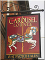
The Carousel Lounge Pub, Hythe
Prospect Road, HYTHE CT21 5JW near The Royal Military Canal
Image: © canalandriversidepubs co uk
Taken: 13 Mar 2010
0.04 miles
5
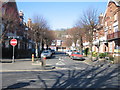
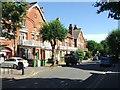
Douglas Avenue
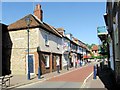
Hythe High Street can be seen at the far end. The High St still retains a certain degree of character with the individual shop managing to survive against the odds.
Image: © Mr Ignavy
Taken: 17 Feb 2008
0.04 miles
7
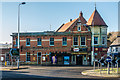
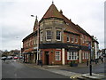
Carousel Lounge
Pub with an Indian and a Chinese restaurant alongside in a building dating from 1903 originally built as a hall for the Loyal Fountain of Friendship Lodge - see Image for its foundation stone.
Image: © Ian Capper
Taken: 14 Jan 2017
0.04 miles
8
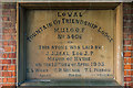
Foundation stone, Carousel Lounge
Foundation stone in the wall of the Carousel Lounge (see Image) referring to the building's original purpose as the hall built in 1903 for the Loval Fountain of Friendship Lodge, part of the Manchester Unity Independent Order of Oddfellows (M.U.I.O.O.F.).
Image: © Ian Capper
Taken: 14 Jan 2017
0.04 miles
9
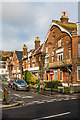
Douglas Avenue
Late Victorian road linking Prospect Road and High Street. The suggestion is that they were built by local brewers, Mackesons, for their senior management.
Image: © Ian Capper
Taken: 16 Jan 2017
0.04 miles
10
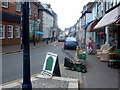
Hythe - High Street
Hythe, High Street looking west. Hythe is a small coastal market town on the edge of Romney Marsh, in the District of Shepway on the south coast of Kent. The word Hythe or Hithe is an Old English word meaning Haven or Landing Place.
Image: © Helmut Zozmann
Taken: 27 Jul 2010
0.04 miles