IMAGES TAKEN NEAR TO
Postling, HYTHE, CT21 4EY
Introduction
This page details the photographs taken nearby to CT21 4EY by members of the Geograph project.
The Geograph project started in 2005 with the aim of publishing, organising and preserving representative images for every square kilometre of Great Britain, Ireland and the Isle of Man.

There are currently over 7.5m images from over14,400 individuals and you can help contribute to the project by visiting https://www.geograph.org.uk
Image Map
Images are licensed for reuse under creativecommons.org/licenses/by-sa/2.0
Notes
- Clicking on the map will re-center to the selected point.
- The higher the marker number, the further away the image location is from the centre of the postcode.
Image Listing (74 Images Found)
Images are licensed for reuse under creativecommons.org/licenses/by-sa/2.0
Image
Details
Distance
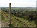
1

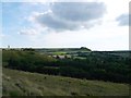
Panorama view from Postling Downs
Seen from Image
The village of Postling (and Ash Wells Wood) is on the left.
Pent Farm is along the Pilgrims Way, in the middle.
The downs is on the right.
Image: © David Anstiss
Taken: 7 Oct 2012
0.02 miles
2
View of Postling, from the Downs
As seen from the North Downs Way (long distance path) on top of the downs.
The Ash Wells woodland is seen before Image
In the far background on the left, Image can be seen, further along the North Downs Way.
Image: © David Anstiss
Taken: 7 Oct 2012
0.07 miles
3
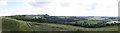
Panorama of Postling
As seen from the North Downs Way (long distance path) on top of the downs.
In the far background, Image can just be seen, further along the North Downs Way.
Image: © David Anstiss
Taken: 7 Oct 2012
0.08 miles
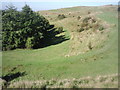
4
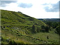
Ridged side of North Downs near Postling
As seen from the North Downs Way (long distance path) on the downs heading towards Etchinghill.
A track leads down the valleyside towards Postling.
Image: © David Anstiss
Taken: 7 Oct 2012
0.09 miles
5
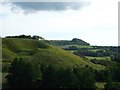
North Downs near Postling
As seen from the North Downs Way (long distance path) on the downs heading towards Etchinghill.
There are many twists and turns to the downs.
Tolsford Hill and woodland is seen in the background.
Image: © David Anstiss
Taken: 7 Oct 2012
0.10 miles
7
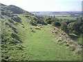
Chalk downland above Postling
The path straight ahead descends to Postling, whilst the North Downs Way continues up the slope on the left.
Image: © Marathon
Taken: 11 Oct 2010
0.10 miles
8
Paths on the chalk downland above Postling
The downland makes fine, easy walking with a variety of possible routes. This view is taken from the North Downs Way.
Image: © Marathon
Taken: 11 Oct 2010
0.10 miles
9
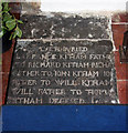
St Mary & St Radegund, Postling, Kent - Ledger slab
Image: © John Salmon
Taken: 14 Sep 2010
0.11 miles
10

St Mary & St Radegund, Postling, Kent - Font
Image: © John Salmon
Taken: 14 Sep 2010
0.11 miles