IMAGES TAKEN NEAR TO
Carters Road, FOLKESTONE, CT20 3PL
Introduction
This page details the photographs taken nearby to Carters Road, CT20 3PL by members of the Geograph project.
The Geograph project started in 2005 with the aim of publishing, organising and preserving representative images for every square kilometre of Great Britain, Ireland and the Isle of Man.

There are currently over 7.5m images from over14,400 individuals and you can help contribute to the project by visiting https://www.geograph.org.uk
Image Map (Loading...)


Getting Data...Please wait
Leaflet Map data © OpenStreetMap
Images are licensed for reuse under creativecommons.org/licenses/by-sa/2.0
Notes
- Clicking on the map will re-center to the selected point.
- The higher the marker number, the further away the image location is from the centre of the postcode.
Image Listing (62 Images Found)
Images are licensed for reuse under creativecommons.org/licenses/by-sa/2.0
Image
Details
Distance
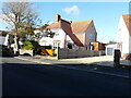
1
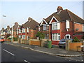
Shorncliffe Road
1930s semis in Coolinge.
Image: © Burgess Von Thunen
Taken: 24 Oct 2012
0.02 miles


6

Volkswagen Microbus Type 1
Volkswagen Microbus Type 1 seen in Folkestone, Cheriton, Cheriton Road.
Image
Image: © Helmut Zozmann
Taken: 22 Jul 2009
0.09 miles
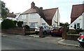
8
32, Shorncliffe Crescent
Planning permission has been approved, with conditions, by Folkestone and Hythe District Council under application number 22/1282/FH for the “erection of first floor extension to front of property”.
The work appears to have begun.
Image: © John Baker
Taken: 9 Nov 2022
0.12 miles
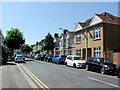
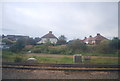
10
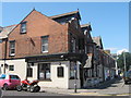
The Royal Cheriton Public House, Folkestone
On junction of 339 Cheriton Road (on right) and St Winifred Road (on left).
Image: © David Anstiss
Taken: 13 Jun 2009
0.13 miles