IMAGES TAKEN NEAR TO
Grimston Gardens, FOLKESTONE, CT20 2UA
Introduction
This page details the photographs taken nearby to Grimston Gardens, CT20 2UA by members of the Geograph project.
The Geograph project started in 2005 with the aim of publishing, organising and preserving representative images for every square kilometre of Great Britain, Ireland and the Isle of Man.

There are currently over 7.5m images from over14,400 individuals and you can help contribute to the project by visiting https://www.geograph.org.uk
Image Map
Images are licensed for reuse under creativecommons.org/licenses/by-sa/2.0
Notes
- Clicking on the map will re-center to the selected point.
- The higher the marker number, the further away the image location is from the centre of the postcode.
Image Listing (117 Images Found)
Images are licensed for reuse under creativecommons.org/licenses/by-sa/2.0
Image
Details
Distance
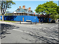
2
12, Jointon Road
This image shows Image in May 2018.
Image: © John Baker
Taken: 6 Oct 2019
0.08 miles
3
36, Earl's Avenue
It would appear, from the boarded up windows, that nobody is living in these self-contained flats.
Image: © John Baker
Taken: 30 Apr 2017
0.08 miles
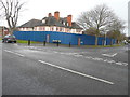
4
12, Jointon Road
Planning permission was approved, with conditions, by Folkestone and Hythe District Council under application number Y15/0178/SH for the “demolition of rear and side extensions and conversion of existing building to form 2 self-contained dwellings and construction of two blocks to the rear garden to form 6 townhouses”.
This image shows Image in March 2017.
Image: © John Baker
Taken: 6 May 2018
0.09 miles
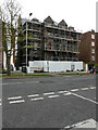
5
12, Jointon Road
Planning permission has been approved, with conditions, by Folkestone and Hythe District Council under application number Y15/0178/SH for the “demolition of rear and side extensions and conversion of existing building to form 2 self-contained dwellings and construction of two blocks to the rear garden to form 6 townhouses”.
Image: © John Baker
Taken: 5 Mar 2017
0.09 miles
6
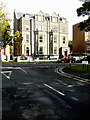
The Wycliffe Hotel, Folkestone
View SE across Bouverie Road West towards the Wycliffe Hotel.
Image: © David P Howard
Taken: 23 Jul 2010
0.10 miles
7
Conversion of Mount Calm, 24-26, Earl's Avenue
Planning permission was approved, with conditions, by Folkestone and Hythe District Council under application number Y16/0813/SH for the “change of use from residential care home (Use class C2) to 11 self contained residential flats (Use Class C3)”.
Image: © John Baker
Taken: 30 Apr 2017
0.10 miles
8
24-26, Earl?s Avenue
This image shows the Image in April 2017.
Image: © John Baker
Taken: 6 Oct 2019
0.10 miles
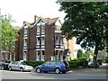
9
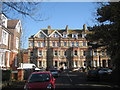
Terraced Houses on Westbourne Gardens
Victorian style with bay windows to ground and first floors.
Image: © Oast House Archive
Taken: 8 Apr 2010
0.11 miles