IMAGES TAKEN NEAR TO
Augusta Gardens, FOLKESTONE, CT20 2RS
Introduction
This page details the photographs taken nearby to Augusta Gardens, CT20 2RS by members of the Geograph project.
The Geograph project started in 2005 with the aim of publishing, organising and preserving representative images for every square kilometre of Great Britain, Ireland and the Isle of Man.

There are currently over 7.5m images from over14,400 individuals and you can help contribute to the project by visiting https://www.geograph.org.uk
Image Map
Images are licensed for reuse under creativecommons.org/licenses/by-sa/2.0
Notes
- Clicking on the map will re-center to the selected point.
- The higher the marker number, the further away the image location is from the centre of the postcode.
Image Listing (365 Images Found)
Images are licensed for reuse under creativecommons.org/licenses/by-sa/2.0
Image
Details
Distance
1
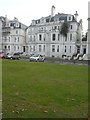
43 & 45, Augusta Gardens
Number 45 is sprouting a fine display of vegetation.
Image: © John Baker
Taken: 30 Oct 2016
0.01 miles
2
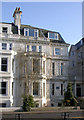
Samuel Plimsoll's house, Augusta Gardens
Former home of Samuel Plimsoll, the Victorian politician who campaigned to have a compulsory loading line on seagoing ships.
Image: © Steve C
Taken: 17 Apr 2010
0.05 miles
3
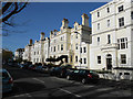
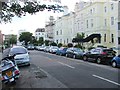
Augusta Gardens, Folkestone
Unusually, this road has one name for one side and another name the other side. Augusta Gardens, as seen here, is on the eastern side of the street and Trinity Gardens is on the west. Google Maps incorrectly states that the entire road is called Trinity Gardens. There's no simple way for cartographers to represent this without taking up a lot of space.
Image: © Danny P Robinson
Taken: 1 Apr 2014
0.05 miles
4
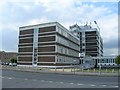
Bouverie House, Kent Police, Folkestone
Bouverie House in Bouverie Road West, the Folkestone facilities of Kent Police.
Image: © David P Howard
Taken: 23 Jul 2010
0.06 miles
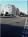
6
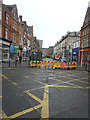
Temporary closure of Sandgate Road
I was standing on a traffic island between Trinity Gardens (to the left) and Clifton Road (to the right). In the distance, a lorry marks the spot where a hole had been dug in the road.
Image: © John Baker
Taken: 2 Jun 2015
0.07 miles
9
Crayford Court, 189, Sandgate Road
It appeared that scaffolding had been erected, on the front of the building, so that the exterior could be redecorated.
Image: © John Baker
Taken: 3 Mar 2016
0.10 miles
10

Looking west-southwest across Castle Hill Avenue
To number 7, which has had scaffolding erected on part of its frontage.
Image: © John Baker
Taken: 4 Feb 2016
0.10 miles