IMAGES TAKEN NEAR TO
Military Road, CANTERBURY, CT1 9TE
Introduction
This page details the photographs taken nearby to Military Road, CT1 9TE by members of the Geograph project.
The Geograph project started in 2005 with the aim of publishing, organising and preserving representative images for every square kilometre of Great Britain, Ireland and the Isle of Man.

There are currently over 7.5m images from over14,400 individuals and you can help contribute to the project by visiting https://www.geograph.org.uk
Image Map
Images are licensed for reuse under creativecommons.org/licenses/by-sa/2.0
Notes
- Clicking on the map will re-center to the selected point.
- The higher the marker number, the further away the image location is from the centre of the postcode.
Image Listing (50 Images Found)
Images are licensed for reuse under creativecommons.org/licenses/by-sa/2.0
Image
Details
Distance
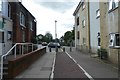
1
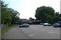
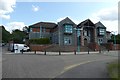
Council offices
Looking towards the council offices from Military Road.
Image: © DS Pugh
Taken: 20 Aug 2019
0.04 miles
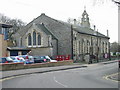
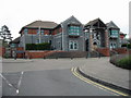
4
All Saints Church
Looking along All Saints Church on Military Road.
Image: © DS Pugh
Taken: 20 Aug 2019
0.08 miles
7
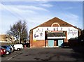
Northgate Ward Community Centre, Canterbury
Situated at the far end of Military Road, the community centre was established in 1997. Although the building that houses it is much older, I am not aware of its original use.
Image: © David Kemp
Taken: 14 Jan 2007
0.13 miles
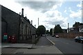
8
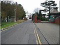
Chaucer Road, no public access beyond this point
Image: © Nick Smith
Taken: 31 Dec 2007
0.13 miles
9
Path to Military Road
Linking through from Brymore Road.
Image: © DS Pugh
Taken: 20 Aug 2019
0.16 miles
10
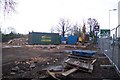
Demolished Fastfood Restaurant
On the A28 Sturry Road, near the Asda / B and Q Warehouse Roundabout.
See http://www.geograph.org.uk/photo/1522374 before the destruction.
Image: © David Anstiss
Taken: 5 Dec 2009
0.17 miles