IMAGES TAKEN NEAR TO
Charles Crescent, FOLKESTONE, CT19 4NG
Introduction
This page details the photographs taken nearby to Charles Crescent, CT19 4NG by members of the Geograph project.
The Geograph project started in 2005 with the aim of publishing, organising and preserving representative images for every square kilometre of Great Britain, Ireland and the Isle of Man.

There are currently over 7.5m images from over14,400 individuals and you can help contribute to the project by visiting https://www.geograph.org.uk
Image Map
Images are licensed for reuse under creativecommons.org/licenses/by-sa/2.0
Notes
- Clicking on the map will re-center to the selected point.
- The higher the marker number, the further away the image location is from the centre of the postcode.
Image Listing (14 Images Found)
Images are licensed for reuse under creativecommons.org/licenses/by-sa/2.0
Image
Details
Distance
1
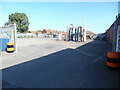
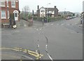
Bus Depot Yard, Cheriton
Taken from Kent Road, this photo shows the vacated bus depot yard with a ADL Dart 38-seater bus dating from 2004 in the distance. This depot closed on Saturday 2nd September 2023 with the buses reallocated to the nearby depots in Ashford and Dover. It remains to be seen what will happen to the former bus depot which was originally owned by the East Kent Road Car Co Ltd. Details of this former bus operator is on the Wikipedia website at https://en.wikipedia.org/wiki/East_Kent_Road_Car_Company.
Image: © David Hillas
Taken: 14 Sep 2023
0.11 miles
2
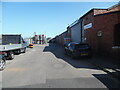
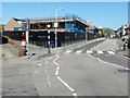
Former Stagecoach Bus Depot, Cheriton
Situated in Kent Road CT19 4NT, this former East Kent Road Car bus depot was closed on Saturday 2nd September 2023 and its allocation of 59 buses reallocated to nearby Ashford (TQ9942) and Dover (TR3044) bus depots. Stagecoach South East who took over the bus operator East Kent in 1993 issued a statement explaining the closure as at https://www.stagecoachbus.com/news/south-east/2023/june/stagecoach-announces-planned-changes-to-folkestone-bus-operations#.
Image: © David Hillas
Taken: 14 Sep 2023
0.12 miles
4
Cherry Pickers, Ashley Avenue
The derelict public house was damaged by fire on 25 May 2014
http://www.kentonline.co.uk/folkestone/news/breaking-news-fire-at-derelict-17746
Image: © John Baker
Taken: 2 Dec 2014
0.15 miles
5
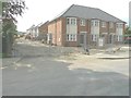
Emory Place, Ashley Avenue
Planning permission has been approved, with conditions, by Folkestone and Hythe District Council under application number Y16/0747/SH for the “erection of nine houses together with associated parking, turning and landscaping, following demolition of the existing building”.
The houses are being built on the site of the Image
Image: © John Baker
Taken: 10 Apr 2019
0.16 miles
8
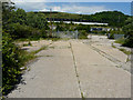
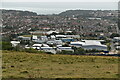
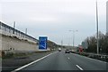
Derelict site, Caesar?s Way
Beyond the site is the M20 motorway and, above it, the Channel Tunnel Terminal.
Image: © John Baker
Taken: 18 Jun 2017
0.21 miles
9
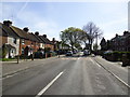
Erection of new houses, Stanley Road
Planning permission has been approved, with conditions, by Folkestone and Hythe District Council under application number Y13/1114/SH for the “erection of ten terraced and four semi-detached dwellings following demolition of existing buildings – variation of condition 15 of planning permission Y11/1057/SH to allow the written assessment”. The dwellings are being built on land adjacent to a former communications centre.
Image: © John Baker
Taken: 1 Jun 2014
0.23 miles