IMAGES TAKEN NEAR TO
Weymouth Terrace, Biggins Wood Road, FOLKESTONE, CT19 4ND
Introduction
This page details the photographs taken nearby to Weymouth Terrace, Biggins Wood Road, CT19 4ND by members of the Geograph project.
The Geograph project started in 2005 with the aim of publishing, organising and preserving representative images for every square kilometre of Great Britain, Ireland and the Isle of Man.

There are currently over 7.5m images from over14,400 individuals and you can help contribute to the project by visiting https://www.geograph.org.uk
Image Map
Images are licensed for reuse under creativecommons.org/licenses/by-sa/2.0
Notes
- Clicking on the map will re-center to the selected point.
- The higher the marker number, the further away the image location is from the centre of the postcode.
Image Listing (11 Images Found)
Images are licensed for reuse under creativecommons.org/licenses/by-sa/2.0
Image
Details
Distance
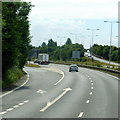
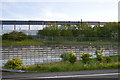
3
M20 Motorway
Past junction 12. The motorway terminates at the next junction 13 and turns into the A20 bypass to Dover.
Image: © Oast House Archive
Taken: 15 Feb 2010
0.14 miles
4
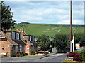
Cheriton - 2007
Cheriton, Firs Close, Cheriton Hill, 'Folkestone White Horse'.
Image: © Helmut Zozmann
Taken: 30 Jul 2007
0.15 miles
6
Cheriton - 2007
Cheriton, Firs Lane, Cheriton Hill, 'Folkestone White Horse'.
Image: © Helmut Zozmann
Taken: 30 Jul 2007
0.17 miles
8
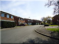
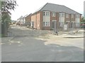
New houses, Stanley Road
Compared with Image, all work on the new houses has been completed. The cul-de-sac running off Stanley Road has been given the name Milky Whey.
Image: © John Baker
Taken: 11 Dec 2014
0.19 miles
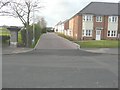
10
Erection of new houses, Stanley Road
Planning permission has been approved, with conditions, by Folkestone and Hythe District Council under application number Y13/1114/SH for the “erection of ten terraced and four semi-detached dwellings following demolition of existing buildings – variation of condition 15 of planning permission Y11/1057/SH to allow the written assessment”. The dwellings are being built on land adjacent to a former communications centre.
Image: © John Baker
Taken: 1 Jun 2014
0.19 miles