IMAGES TAKEN NEAR TO
Acrise, FOLKESTONE, CT18 8LN
Introduction
This page details the photographs taken nearby to CT18 8LN by members of the Geograph project.
The Geograph project started in 2005 with the aim of publishing, organising and preserving representative images for every square kilometre of Great Britain, Ireland and the Isle of Man.

There are currently over 7.5m images from over14,400 individuals and you can help contribute to the project by visiting https://www.geograph.org.uk
Image Map
Images are licensed for reuse under creativecommons.org/licenses/by-sa/2.0
Notes
- Clicking on the map will re-center to the selected point.
- The higher the marker number, the further away the image location is from the centre of the postcode.
Image Listing (46 Images Found)
Images are licensed for reuse under creativecommons.org/licenses/by-sa/2.0
Image
Details
Distance
1
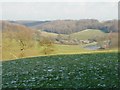
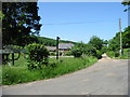
Rakesole Farm
A zoom shot taken from the bridleway past Standardhill Plantation in Image
Image: © John Baker
Taken: 15 Jan 2013
0.01 miles
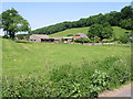
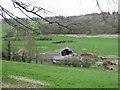
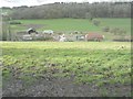
4
The countryside around Rakesole Farm
Only the outbuildings are visible but perched on the hillside above is the house that comprises Golden Hill Shaw. Both set in The North Downs ANOB (Area of Outstanding Natural Beauty).
Image: © John Baker
Taken: 8 Aug 2012
0.01 miles
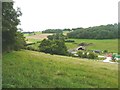
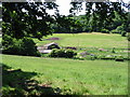
5
Farm track and footpath past Rakesole Farm
Image: © Nick Smith
Taken: 9 Jun 2008
0.02 miles
6
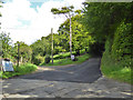
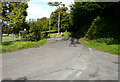
New road surface up the hill
The way to the left of the tall tree is a public byway.
Image: © Robin Webster
Taken: 2 Sep 2017
0.03 miles
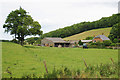
7
Looking through the trees to Rakeshole Farm
Similar shot to http://www.geograph.org.uk/photo/360094 taken 15 months later
Image: © Nick Smith
Taken: 9 Jun 2008
0.03 miles
9
Reece Lane leading to Blandred Farm
The gradient is very steep but the lane was resurfaced with two layers of micro-asphalt at the beginning of September 2017.
Image: © John Baker
Taken: 17 Sep 2017
0.03 miles
10
Further work on the Affinity Water site
I thought work had been Image on this site but there was signs of activity as I walked down the hill towards Rakesole Farm.
Image: © John Baker
Taken: 10 Feb 2014
0.04 miles