IMAGES TAKEN NEAR TO
Elvington Lane, FOLKESTONE, CT18 7AF
Introduction
This page details the photographs taken nearby to Elvington Lane, CT18 7AF by members of the Geograph project.
The Geograph project started in 2005 with the aim of publishing, organising and preserving representative images for every square kilometre of Great Britain, Ireland and the Isle of Man.

There are currently over 7.5m images from over14,400 individuals and you can help contribute to the project by visiting https://www.geograph.org.uk
Image Map
Images are licensed for reuse under creativecommons.org/licenses/by-sa/2.0
Notes
- Clicking on the map will re-center to the selected point.
- The higher the marker number, the further away the image location is from the centre of the postcode.
Image Listing (19 Images Found)
Images are licensed for reuse under creativecommons.org/licenses/by-sa/2.0
Image
Details
Distance
1
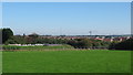
New Houses in Hawkinge
As seen from a footpath from Paddlesworth towards Elvington Lane.
All the new housing you can see is on a former Battle of Britain airfield which finally closed in the 60's. This is one of the largest housing developments in Kent.
Image: © David Anstiss
Taken: 10 Oct 2010
0.04 miles
2
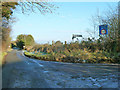
Gibraltar Lane meets Elvington Lane
The signpost only gives a destination for straight on - Hawkinge. The other ways just name the lane involved - a fair assessment for behind the camera, which goes nowhere in particular at first, but a bit harsh for Gibraltar Lane, which offers the shortest way to Folkestone from this point.
Image: © Robin Webster
Taken: 16 Jan 2013
0.06 miles
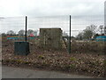
3
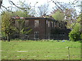
Ruins of Hawkinge Campsite
This is one of a couple of ruined buildings in Hawkinge on the site of a large RAF Base and Airfield. The airfield is now mostly a large housing estate.
Image: © David Anstiss
Taken: 25 Apr 2009
0.09 miles
4
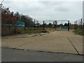
Land at Aerodrome Road & Elvington Lane
Viewed from Aerodrome Road, there is a proposal to build 110 houses on this derelict site, where a former officers mess once stood.
Image: © John Baker
Taken: 5 Mar 2023
0.11 miles
5
Land at Aerodrome Road & Elvington Lane
Viewed from Elvington Lane, there is a proposal to build 110 houses on this derelict site, where a former officers mess once stood.
Image: © John Baker
Taken: 5 Mar 2023
0.12 miles
6
White Hall
Not so white hall, as seen from a footpath from Paddlesworth to Elvington Lane.
Image: © David Anstiss
Taken: 10 Oct 2010
0.16 miles
7
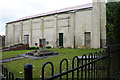
War Memorial
War Memorial in front of a dis-used building.
Image: © Barry Ephgrave
Taken: 29 May 2011
0.17 miles
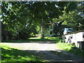
8
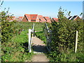
New footpath into Hawkinge Housing Development
Leading from Gibraltar Lane is a footpath around a landscaped section around the large housing estate.
Image: © David Anstiss
Taken: 10 Oct 2010
0.17 miles
9
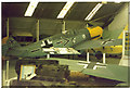
Kent Battle of Britain Museum, Hawkinge
A cramped, but interesting, display of material relating to the Battle of Britain.
Image: © Ron Hann
Taken: Unknown
0.19 miles
10
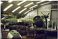
Kent Battle of Britain Museum, Hawkinge
Ample, natural, lighting helps the display.
Image: © Ron Hann
Taken: Unknown
0.19 miles