IMAGES TAKEN NEAR TO
Old Farm Road, CT16 3QT
Introduction
This page details the photographs taken nearby to Old Farm Road, CT16 3QT by members of the Geograph project.
The Geograph project started in 2005 with the aim of publishing, organising and preserving representative images for every square kilometre of Great Britain, Ireland and the Isle of Man.

There are currently over 7.5m images from over14,400 individuals and you can help contribute to the project by visiting https://www.geograph.org.uk
Image Map
Images are licensed for reuse under creativecommons.org/licenses/by-sa/2.0
Notes
- Clicking on the map will re-center to the selected point.
- The higher the marker number, the further away the image location is from the centre of the postcode.
Image Listing (33 Images Found)
Images are licensed for reuse under creativecommons.org/licenses/by-sa/2.0
Image
Details
Distance
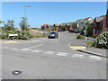
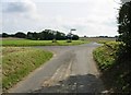
1
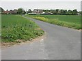
Junction of Church Whitfield Road on to Napchester Road
Image: © Nick Smith
Taken: 5 May 2007
0.09 miles
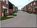
2
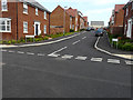
Harvest Road
This is Image with a house still to be built on the corner of the housing estate called Bowmans Place.
Image: © John Baker
Taken: 20 Aug 2017
0.09 miles
3
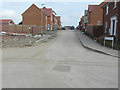
Harvest Road
This road is at the far end of Image on a new housing estate, still under construction, called Bowmans Place. Planning permission has been granted by Dover District Council under application number DOV/13/00607 for “reserved matters application for 74 dwellings (landscaping, access, scale, layout and appearance) details pursuant to outline permission DOV/10/1011 phase 1A (amended details)”. The location is described as Site at Phase 1A - Whitfield Urban Extension.
Image: © John Baker
Taken: 20 Mar 2016
0.09 miles
4
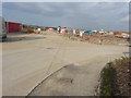
Building site
This site is to the left of Image, at the far end of Image on a new housing estate, still under construction, called Bowmans Place. Planning permission has been granted by Dover District Council under application number DOV/13/00607 for a “reserved matters application for 74 dwellings (landscaping, access, scale, layout and appearance) details pursuant to outline permission DOV/10/1011 phase 1A (amended details)”. The location is described as Site at Phase 1A - Whitfield Urban Extension.
Image: © John Baker
Taken: 20 Mar 2016
0.09 miles
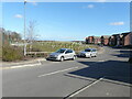
5
Arable Road
This is on the housing estate called Bowmans Place.
Image: © John Baker
Taken: 20 Aug 2017
0.09 miles
6
Field View Road
The mound of earth, to the left of the car, may have been excavated from the site of the Image; it has spoiled the appearance of the former verge of Image
Image: © John Baker
Taken: 28 Jun 2020
0.13 miles
7
Field View Road
The mound of earth in the view of Image has been planted with sapling trees, protected by tuley tubes.
Image: © John Baker
Taken: 6 Mar 2021
0.14 miles
8
Field Road View
All traces of Abbey’s advertising boards have disappeared from the entrance to Image on the housing estate called Bowmans Place.
Image: © John Baker
Taken: 20 Aug 2017
0.14 miles
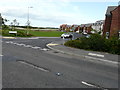
9
Crossroads on Napchester and Church Whitfield roads
Image: © Nick Smith
Taken: 13 Sep 2008
0.14 miles
10

Field View Road
The road leads into a new housing estate, still under construction, called Bowmans Place. Planning permission has been granted by Dover District Council under application number DOV/13/00607 for “reserved matters application for 74 dwellings (landscaping, access, scale, layout and appearance) details pursuant to outline permission DOV/10/1011 phase 1A (amended details)”. The location is described as Site at Phase 1A - Whitfield Urban Extension.
Image: © John Baker
Taken: 16 Feb 2016
0.15 miles