IMAGES TAKEN NEAR TO
Kingsdown Road, DEAL, CT14 8AS
Introduction
This page details the photographs taken nearby to Kingsdown Road, CT14 8AS by members of the Geograph project.
The Geograph project started in 2005 with the aim of publishing, organising and preserving representative images for every square kilometre of Great Britain, Ireland and the Isle of Man.

There are currently over 7.5m images from over14,400 individuals and you can help contribute to the project by visiting https://www.geograph.org.uk
Image Map
Images are licensed for reuse under creativecommons.org/licenses/by-sa/2.0
Notes
- Clicking on the map will re-center to the selected point.
- The higher the marker number, the further away the image location is from the centre of the postcode.
Image Listing (74 Images Found)
Images are licensed for reuse under creativecommons.org/licenses/by-sa/2.0
Image
Details
Distance
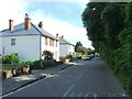
1
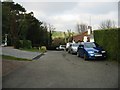
Church Cliff, northern end
The road ends just beyond this point but a footpath continues towards Walmer.
Image: © Nick Smith
Taken: 27 Dec 2008
0.05 miles
2
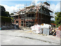
Erection of a house, Balmoral Road
Planning permission was granted by Dover District Council under application number DOV/17/00371 for the “erection of a detached dwelling incorporating an integral garage and construction of a vehicular access”. The location was given as land adjoining 49, Balmoral Road.
Image: © John Baker
Taken: 16 Jul 2017
0.06 miles
3
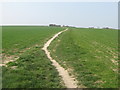
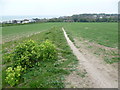
Footpath to Walmer
A path leads from Church Cliff in Kingsdown, towards Hawkshill Freedown, a chalk grassland near Walmer.
Image: © David Anstiss
Taken: 27 Mar 2011
0.08 miles
5
Path towards Kingsdown
The path descends from Hawkshill Freedown to reach Kingsdown ahead.
Image: © Marathon
Taken: 2 May 2015
0.13 miles
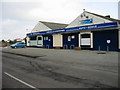
6
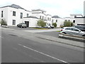
Beach Mews, Kingsdown Road
This development was erected on the site of Image
Planning permission was granted by Dover District Council under application number DOV/11/00664 for the “erection of 7 detached dwellings and construction of a vehicular access”. The location was given as Campbells Garage, 143, Kingsdown Road.
Image: © John Baker
Taken: 16 Jul 2017
0.13 miles
7
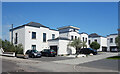
Beach Mews, Kingsdown
A smart new housing development off Kingsdown Road.
Image: © Des Blenkinsopp
Taken: 13 Jun 2021
0.13 miles
10
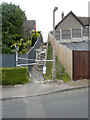
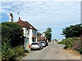
Closed footpath
A notice, affixed to the handrail at the bottom of the steps, gave members of the public to understand that footpath ER3 would be closed from 6 July 2017 for no more than 21 days. Also that the path was closed between Sea Road and Clim Down because of potential danger to the public while the problem was resolved/repairs undertaken. A map, below the notice, indicated that the alternative route was by road. This entailed walking to the end of King’s Close and into Glen Road. Here it was a right turn and then, after a few paces, another right turn into Sea Road to follow this road until the steps were reached.
Image: © John Baker
Taken: 16 Jul 2017
0.14 miles