IMAGES TAKEN NEAR TO
Bridge Road, DEAL, CT14 6PQ
Introduction
This page details the photographs taken nearby to Bridge Road, CT14 6PQ by members of the Geograph project.
The Geograph project started in 2005 with the aim of publishing, organising and preserving representative images for every square kilometre of Great Britain, Ireland and the Isle of Man.

There are currently over 7.5m images from over14,400 individuals and you can help contribute to the project by visiting https://www.geograph.org.uk
Image Map
Images are licensed for reuse under creativecommons.org/licenses/by-sa/2.0
Notes
- Clicking on the map will re-center to the selected point.
- The higher the marker number, the further away the image location is from the centre of the postcode.
Image Listing (363 Images Found)
Images are licensed for reuse under creativecommons.org/licenses/by-sa/2.0
Image
Details
Distance
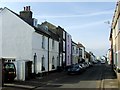
1
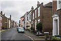
Sandown Road
A north/south road running into Alfred Square and then Middle Street, seen in the background in this photo. In fact the 1872 1:2500 map names it as Middle Street too, it not being until the 1898 map that it is shown with its current name. The tall chimney is of a former bakehouse - see Image
Image: © Ian Capper
Taken: 25 Jan 2014
0.01 miles
2
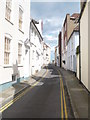
Farrier Street, Deal
Viewed from Middle Street looking towards Beach Street and the sea.
Image: © pam fray
Taken: 25 Jul 2009
0.03 miles
3
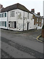
33, Enfield Road
The house also stands on the corner of Sandown Road.
Image: © John Baker
Taken: 5 Feb 2017
0.03 miles
6
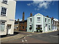
Cavendish House, Deal
On the corner of North Street and Sandown Road.
Image: © pam fray
Taken: 3 Jul 2016
0.04 miles
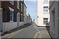
7
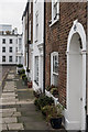
Alfred Square
Houses on the north side of Alfred Square.
Image: © Ian Capper
Taken: 25 Jan 2014
0.04 miles
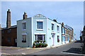
8
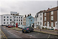
Alfred Square
In the background is Lloyd Court, built in 1901 and formerly Deal College, before being converted in 1911 to a convalescent home for members of the printing profession. The two brick faced buildings on the right and the two parts of the white building next to them date from the 19th century and are all grade II listed - from right to left:
Nos 5 & 6 - see www.historicengland.org.uk/listing/the-list/list-entry/1069900
No 4 - see www.historicengland.org.uk/listing/the-list/list-entry/1363443
No 3 - see www.historicengland.org.uk/listing/the-list/list-entry/1069900
The K6 telephone box is also grade II listed - see www.historicengland.org.uk/listing/the-list/list-entry/1254065.
Image: © Ian Capper
Taken: 25 Jan 2014
0.04 miles
9
Cavendish House, Alfred Square
At the north east corner of the square in an area of smartly restored old properties to the north of Deal town centre.
Image: © Des Blenkinsopp
Taken: 17 Jun 2021
0.04 miles
10
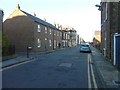
Looking north-northwest along College Road
The nameplate on the left is that of Ark Lane, while the tall house, beyond the terrace, is number 11, whose frontage is clad in scaffolding to enable maintenance to be carried out.
Image: © John Baker
Taken: 10 Nov 2013
0.04 miles