IMAGES TAKEN NEAR TO
The Street, DEAL, CT14 0DJ
Introduction
This page details the photographs taken nearby to The Street, CT14 0DJ by members of the Geograph project.
The Geograph project started in 2005 with the aim of publishing, organising and preserving representative images for every square kilometre of Great Britain, Ireland and the Isle of Man.

There are currently over 7.5m images from over14,400 individuals and you can help contribute to the project by visiting https://www.geograph.org.uk
Image Map
Images are licensed for reuse under creativecommons.org/licenses/by-sa/2.0
Notes
- Clicking on the map will re-center to the selected point.
- The higher the marker number, the further away the image location is from the centre of the postcode.
Image Listing (33 Images Found)
Images are licensed for reuse under creativecommons.org/licenses/by-sa/2.0
Image
Details
Distance
1
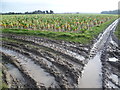
A field of sprouts next to Goretop Lane
This field of sprouts is opposite a house called Little Temptye and alongside Goretop Lane. The crop of sprouts made an impressive sight but recent rain had turned parts of the field into a quagmire.
The White Cliffs Country Trail follows Goretop Lane here. The White Cliffs Trails were created in 1987 by Dover District Council to link the towns of Dover, Deal and Sandwich, going along the white cliffs to the east of Dover to Deal with an inland return through the Kent countryside to include Sandwich. See http://www.bertuchi.co.uk/whitecliff03.php for some photographs of this part of the Trail.
Image: © Marathon
Taken: 25 Jan 2014
0.03 miles
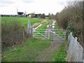
2
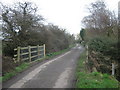
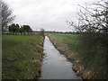
Brewer's Bridge
This bridge over a drainage channel is on Goretop Lane (from Worth to the North Stream).
Image: © David Anstiss
Taken: 13 Feb 2011
0.04 miles
3
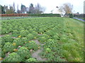
A field of kale next to Goretop Lane
This field of kale is next to a house called Little Temptye which can be seen ahead. Goretop Lane can be seen to the right.
The White Cliffs Country Trail follows Goretop Lane here. The White Cliffs Trails were created in 1987 by Dover District Council to link the towns of Dover, Deal and Sandwich, going along the white cliffs to the east of Dover to Deal with an inland return through the Kent countryside to include Sandwich. See http://www.bertuchi.co.uk/whitecliff03.php for some photographs of this part of the Trail.
Image: © Marathon
Taken: 25 Jan 2014
0.04 miles
4
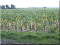
A field of sprouts
This field of sprouts is opposite a house called Little Temptye and alongside Goretop Lane. The crop of sprouts made an impressive sight but recent rain had turned parts of the field into a quagmire.
The White Cliffs Country Trail follows Goretop Lane here. The White Cliffs Trails were created in 1987 by Dover District Council to link the towns of Dover, Deal and Sandwich, going along the white cliffs to the east of Dover to Deal with an inland return through the Kent countryside to include Sandwich. See http://www.bertuchi.co.uk/whitecliff03.php for some photographs of this part of the Trail.
Image: © Marathon
Taken: 25 Jan 2014
0.04 miles
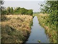
5
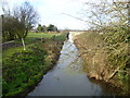
The Delf near Temptye
This drainage channel leads from Goretop Lane towards Sandwich.
As seen from Brewer's Bridge on Goretop Lane.
Image: © David Anstiss
Taken: 13 Feb 2011
0.04 miles
6
The Delph seen from Goretop Lane
This drainage ditch is called The Delph and is seen here from the White Cliffs Country Trail which follows Goretop Lane here.
The White Cliffs Trails were created in 1987 by Dover District Council to link the towns of Dover, Deal and Sandwich, going along the white cliffs to the east of Dover to Deal with an inland return through the Kent countryside to include Sandwich. See http://www.bertuchi.co.uk/whitecliff03.php for some photographs of this part of the Trail.
Other photographs of the Delph can be seen at http://www.geograph.org.uk/photo/3827803 and http://www.geograph.org.uk/photo/3827854
Image: © Marathon
Taken: 25 Jan 2014
0.05 miles
7
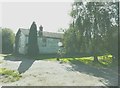
Highfield, Goretop Lane, Worth
Planning permission has been granted by Dover District Council under application number DOV/12/00166 for the “erection of a detached dwelling (existing dwelling to be demolished)”.
Image: © John Baker
Taken: 25 Sep 2011
0.05 miles
8
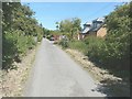
Looking east-southeast along Goretop Lane
On the right is the dwelling known as Highfield that replaced Image At present, it is surrounded by a high wire fence and appears to be uninhabited.
Image: © John Baker
Taken: 2 Jul 2014
0.06 miles
9
Looking SW from railway crossing to Blue Pigeons Farm
Image: © Nick Smith
Taken: 24 Feb 2007
0.06 miles
10
View along The Delf from Brewer's Bridge
Image: © Nick Smith
Taken: 7 Oct 2007
0.06 miles