IMAGES TAKEN NEAR TO
Port Richborough Business Park, Ramsgate Road, SANDWICH, CT13 9PQ
Introduction
This page details the photographs taken nearby to Port Richborough Business Park, Ramsgate Road, CT13 9PQ by members of the Geograph project.
The Geograph project started in 2005 with the aim of publishing, organising and preserving representative images for every square kilometre of Great Britain, Ireland and the Isle of Man.

There are currently over 7.5m images from over14,400 individuals and you can help contribute to the project by visiting https://www.geograph.org.uk
Image Map
Images are licensed for reuse under creativecommons.org/licenses/by-sa/2.0
Notes
- Clicking on the map will re-center to the selected point.
- The higher the marker number, the further away the image location is from the centre of the postcode.
Image Listing (37 Images Found)
Images are licensed for reuse under creativecommons.org/licenses/by-sa/2.0
Image
Details
Distance
1
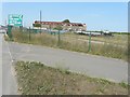
Corrugated iron building
Seen across Stonar Cut. The building sits on a site that it used for recycling waste masterials such a plastic bottles, cardboard and paper. There is a large boat moored beside it in the cut.
Image: © John Baker
Taken: 27 Aug 2013
0.01 miles

3
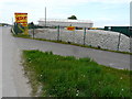
A SKIP 4 U, Ramsgate Road
A Skip 4 U have been independently trading from their site in Sandwich since 1984 and employ a force of local drivers. Their fleet of specially designed lorries [also] come in many sizes – they even have ones that are compact and perfect for those hard to access sites and driveways. They can also lift and tip over medium size walls.
All of the waste materials are taken back to their recycling centre in Sandwich where it all gets hand sorted into the different waste categories to be dealt with and recycled appropriately https://www.a-skip4u.com/about-us
Note: the large, rectangular shed in the background has received a thorough refurbishment. It used to be a very decrepit Image
Image: © John Baker
Taken: 2 May 2019
0.03 miles
4
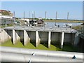
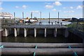
The sluice at Stonar Cut
With a large boat moored beyond. Following a report by Murdock Mackenzie (Maritime Surveyor of His Majesty’s Service) in 1775, The Stonar Cut Act of 1776 was passed enabling a channel controlled by floodgates to be constructed across the neck of a large loop in the River Stour. When there is prolonged heavy rain and the flow in the river is running full, the Stonar Cut gates are opened and part of the flow is diverted down the Stonar Cut direct to the sea, bypassing the town of Sandwich. When this operation is carried out, it is known as ‘running the cut’ and, although the gates are worked by electric motor now, this method of lowering water levels in the river is still used. This operation benefits approximately 3000 acres of land http://www.riverstouridb.org.uk/history.php
I noticed in the link that the River Stour had been referred to as the River Great Stour. I wrote to the Clerk of the Board (contact us, on the website) pointing this out and while he was in agreement with me that it should be the River Stour, he didn’t twig that a change should be made to the text. However, I have referred to it as the River Stour in my description
Image: © John Baker
Taken: 27 Aug 2013
0.04 miles


9
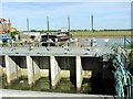
Stonar Cut and the A256 crossing
Opened in 1776 the Stonar Cut formed a shortcut across the neck of the Sandwich Loop on the River Stour so that floodwater caused by high rainfall or a high spring tide could take the shortest route to the sea without flooding Sandwich. Its sluice gates were renewed in 1999 and for 175 years the gates were manned fulltime.
Image: © Nick Smith
Taken: 2 Jun 2007
0.06 miles