IMAGES TAKEN NEAR TO
Sandown Lees, SANDWICH, CT13 9NZ
Introduction
This page details the photographs taken nearby to Sandown Lees, CT13 9NZ by members of the Geograph project.
The Geograph project started in 2005 with the aim of publishing, organising and preserving representative images for every square kilometre of Great Britain, Ireland and the Isle of Man.

There are currently over 7.5m images from over14,400 individuals and you can help contribute to the project by visiting https://www.geograph.org.uk
Image Map
Images are licensed for reuse under creativecommons.org/licenses/by-sa/2.0
Notes
- Clicking on the map will re-center to the selected point.
- The higher the marker number, the further away the image location is from the centre of the postcode.
Image Listing (22 Images Found)
Images are licensed for reuse under creativecommons.org/licenses/by-sa/2.0
Image
Details
Distance

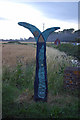
8
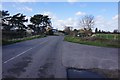
National Cycle Network Milepost near New Cut Bridge
This mile post is on Guilford Road National Cycle Network 1 between Sandwich and Deal.
In the background is New Cut Stream beside New Downs Farm access road.
Image: © David Anstiss
Taken: 10 Apr 2011
0.15 miles
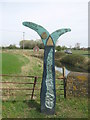
9
National Cycle Network sign, Guilford Road near Sandwich
Taken just after sunset, this is the sign visible to the right of the bridge in Image Guilford Road forms part of National Cycle Network Route 1. On the right is North Stream and in the far distance are the towers of the disused Richborough power station.
Image: © Ian Capper
Taken: 22 Jul 2008
0.15 miles
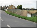
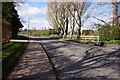
10
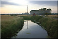
North Stream, near Sandwich
Viewed from the Guilford Road Bridge, by the junction with the Royal St George's Golf Club access road (on right). Taken just after sunset, with mist forming in front of the trees. In the far distance can be seen the towers of the disused Richborough power station.
Image: © Ian Capper
Taken: 22 Jul 2008
0.16 miles