IMAGES TAKEN NEAR TO
Richborough Road, SANDWICH, CT13 9JE
Introduction
This page details the photographs taken nearby to Richborough Road, CT13 9JE by members of the Geograph project.
The Geograph project started in 2005 with the aim of publishing, organising and preserving representative images for every square kilometre of Great Britain, Ireland and the Isle of Man.

There are currently over 7.5m images from over14,400 individuals and you can help contribute to the project by visiting https://www.geograph.org.uk
Image Map
Images are licensed for reuse under creativecommons.org/licenses/by-sa/2.0
Notes
- Clicking on the map will re-center to the selected point.
- The higher the marker number, the further away the image location is from the centre of the postcode.
Image Listing (94 Images Found)
Images are licensed for reuse under creativecommons.org/licenses/by-sa/2.0
Image
Details
Distance


4
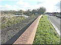
Flood prevention wall, Richborough Road
That has been built, as part of the Sandwich Town Tidal Defence Scheme, beside the River Stour, seen here to its left.
Image: © John Baker
Taken: 19 Nov 2013
0.05 miles
5
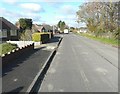
Looking north-northwest along Richborough Road
In the direction of the Image seen here as a pale strip to the right of the road. In August 2013, it appeared as the Image It is part of Sandwich Town Tidal Defence Scheme.
Image: © John Baker
Taken: 19 Nov 2013
0.06 miles
6
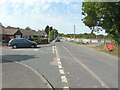
Installation of steel sheet piling along Richborough Road
As reported in “recent work - updated August 2013”, steel sheet piling has been completed along Reach 2 near Richborough Road as part of the Sandwich Town Tidal Defence Scheme
http://www.environment-agency.gov.uk/homeandleisure/floods/111320.aspx
I was standing on the corner of Wantsume Lees looking across at the work in hand on the right hand side of Richborough Road.
Image: © John Baker
Taken: 27 Aug 2013
0.07 miles
7
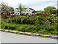
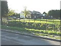
North Polders Farm, Richborough Road
This was Image in November 2013, when building work was ongoing.
Image: © John Baker
Taken: 9 May 2021
0.08 miles

9
North Poulders Farm, Richborough Road
Work is being carried out to the right side of the house (number 2, North Poulders Farm). Planning permission has been granted by Dover District Council under application number DOV/13/00201 for the “erection of a detached garage”.
This was Image in May 2021.
Image: © John Baker
Taken: 19 Nov 2013
0.09 miles
