IMAGES TAKEN NEAR TO
Mulberry Field, SANDWICH, CT13 9DJ
Introduction
This page details the photographs taken nearby to Mulberry Field, CT13 9DJ by members of the Geograph project.
The Geograph project started in 2005 with the aim of publishing, organising and preserving representative images for every square kilometre of Great Britain, Ireland and the Isle of Man.

There are currently over 7.5m images from over14,400 individuals and you can help contribute to the project by visiting https://www.geograph.org.uk
Image Map
Images are licensed for reuse under creativecommons.org/licenses/by-sa/2.0
Notes
- Clicking on the map will re-center to the selected point.
- The higher the marker number, the further away the image location is from the centre of the postcode.
Image Listing (652 Images Found)
Images are licensed for reuse under creativecommons.org/licenses/by-sa/2.0
Image
Details
Distance
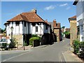
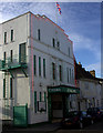
2
The Old Drum, Church Street St. Mary
One of the buildings to earn a "Historic Buildings of Kent" plaque. Circa 1450.
Image: © pam fray
Taken: 25 Feb 2008
0.04 miles
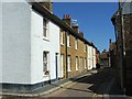
3
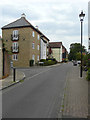
Looking south-southwest along Loop Street
The next road to the left is a cul-de-sac called Stour Court.
Image: © John Baker
Taken: 23 Aug 2015
0.05 miles
7
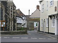
Looking SW along Church Street St Mary's
St Mary's church on the left and the Kings Arms on the right where the road joins Strand Street.
Image: © Nick Smith
Taken: 4 Apr 2009
0.05 miles
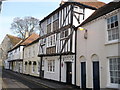
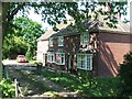
9
Villa, 13, Church Street St Mary?s
Planning permission has been granted by Dover District Council under application number DOV/18/01280 for the “erection of a single storey rear extension, erection of a garden wall with re-located gates and replacement of windows (chimney and existing garden wall to be demolished)”.
This is Image from the back.
Image: © John Baker
Taken: 13 Jan 2019
0.06 miles
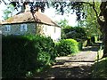
10
Villa, 13, Church Street St Mary?s
Planning permission has been granted by Dover District Council under application number DOV/18/01280 for the “erection of a single storey rear extension, erection of a garden wall with re-located gates and replacement of windows (chimney and existing garden wall to be demolished)”.
This is Image from the side, while this image shows the back of the house.
Image: © John Baker
Taken: 13 Jan 2019
0.06 miles