IMAGES TAKEN NEAR TO
Mill Lane, SANDWICH, CT13 0JS
Introduction
This page details the photographs taken nearby to Mill Lane, CT13 0JS by members of the Geograph project.
The Geograph project started in 2005 with the aim of publishing, organising and preserving representative images for every square kilometre of Great Britain, Ireland and the Isle of Man.

There are currently over 7.5m images from over14,400 individuals and you can help contribute to the project by visiting https://www.geograph.org.uk
Image Map
Images are licensed for reuse under creativecommons.org/licenses/by-sa/2.0
Notes
- Clicking on the map will re-center to the selected point.
- The higher the marker number, the further away the image location is from the centre of the postcode.
Image Listing (231 Images Found)
Images are licensed for reuse under creativecommons.org/licenses/by-sa/2.0
Image
Details
Distance
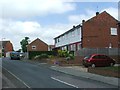
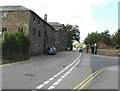
3
Eastry hospital on Mill Lane
Eastry Hospital, formerly a workhouse and finally a mental hospital. Eastry Poor Law Union officially came into existence on 27th April 1835.
Architect William Spanton – (workhouse part)
Patients 500 (as a workhouse)
Finally closed in 1997, due for demolition autumn 2007 although this wing may be preserved.
Image: © Nick Smith
Taken: 29 Sep 2007
0.02 miles
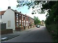
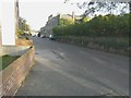
5
Former Eastry Hospital in Mill Lane
The road leaving Mill Lane in this picture is called Wheelwrights Way. The windows of the hospital overlooking Mill Lane have been boarded up. There appears to have been fire damage to part of the building. Planning permission has been granted by Dover District Council under application number DOV/14/00241 for the “minor demolition, and refurbishment/conversion of the Old Workhouse to provide 10 residential units; alterations and conversion of Tewkesbury House and the former Chapel to provide for community and employment space; reinstatement of the former Range building to provide a two storey terrace of 10 residential units (amended description and plans)”.
Image: © John Baker
Taken: 30 Aug 2009
0.03 miles
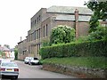
6
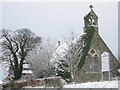
Eastry Hospital Chapel
On Mill Lane. Hospital was a former workhouse.
Now the whole site is about to be re-developed by Runnymede Investments.
Image: © David Anstiss
Taken: 19 Dec 2010
0.03 miles
7
Former Eastry Hospital, Mill Lane
On 26 August 2012, BBC News Kent reported that the roof of the building had been destroyed by fire earlier that day http://www.bbc.co.uk/news/uk-england-kent-19385608
The BBC report in this link refers to the site as the former Rivendell Hospital. The site is actually that of the former Eastry Hospital. There is a separate building called Rivendell adjacent to the site. This building is currently still in use (I am indebted to David Mastin
for this information).
Image: © John Baker
Taken: 30 Oct 2013
0.03 miles
8
Former Eastry Hospital, Mill Lane
On 26 August 2012, BBC News Kent reported that the roof of the building had been destroyed by fire earlier that day http://www.bbc.co.uk/news/uk-england-kent-19385608 This is how the building appeared in 2009 Image The BBC report in this link refers to the site as the former Rivendell Hospital. The site is actually that of the former Eastry Hospital. There is a separate building called Rivendell adjacent to the site. This building is currently still in use (I am indebted to David Mastin for this information).
Image: © John Baker
Taken: 8 Sep 2013
0.03 miles
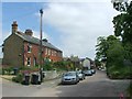
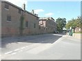
9
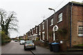
Providence Chapel and Mill Lane Cottages
Late 18th century terrace, with end building added in 1822 as a Wesleyan chapel - a plaque on the wall states "Providence Chapel 1822". Grade II listed - see www.historicengland.org.uk/listing/the-list/list-entry/1363275.
Image: © Ian Capper
Taken: 25 Jan 2014
0.03 miles
10
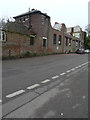
Eastry Hospital, Mill Lane
This image of the Image shows more of the building was standing in December 2015 than it is now and yet motorists still park beside it.
Image: © John Baker
Taken: 24 Dec 2017
0.04 miles