IMAGES TAKEN NEAR TO
Creine Mill Lane North, CANTERBURY, CT1 2FP
Introduction
This page details the photographs taken nearby to Creine Mill Lane North, CT1 2FP by members of the Geograph project.
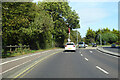
The Geograph project started in 2005 with the aim of publishing, organising and preserving representative images for every square kilometre of Great Britain, Ireland and the Isle of Man.

There are currently over 7.5m images from over14,400 individuals and you can help contribute to the project by visiting https://www.geograph.org.uk
Image Map
Images are licensed for reuse under creativecommons.org/licenses/by-sa/2.0
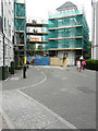
Notes
- Clicking on the map will re-center to the selected point.
- The higher the marker number, the further away the image location is from the centre of the postcode.
Image Listing (1231 Images Found)
Images are licensed for reuse under creativecommons.org/licenses/by-sa/2.0
Image
Details
Distance
1
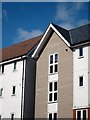
New Housing, Canterbury
A whole new neighbourhood has been created to the west of the city centre between the Great Stour and the by-pass.
A lot of design variation and a non linear street plan has been used to avoid a "new estate" look.
Image: © Des Blenkinsopp
Taken: 28 Aug 2011
0.01 miles
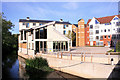
2
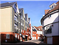
New homes at The Old Tannery
Recently completed homes constructed by Bellway Homes.
Image: © Oast House Archive
Taken: 20 Apr 2012
0.02 miles
3
Apartments on Old Watling Street
Image: © Oast House Archive
Taken: 20 Apr 2012
0.03 miles
4
A2050 Rheims Way, Canterbury
A more ring-like bit of a Canterbury ring road system. Some maps label this stretch as the A290.
Image: © Robin Webster
Taken: 13 Oct 2018
0.04 miles
5
Old Watling Street
It appears that the apartments on both sides of the road, which are part of the St Mildred’s Tannery development, may be undergoing external renovation.
Image: © John Baker
Taken: 4 Aug 2019
0.04 miles
6
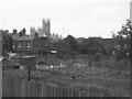
Allotments, Canterbury, 1965
The allotments are no longer there - they have been built over with housing around the line of Old Watling Street, and the terraces on St Peter's Grove on the left now join onto the new estate. As with the allotments, I think wherever I was standing when I took this has also changed fundamentally - I suspect it is now Rheims Way. However, the cathedral is still there.
Image: © Derek Harper
Taken: Unknown
0.04 miles
7
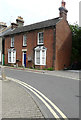
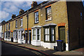
St Peters Villa, 59, St Peter?s Grove
The house had an air of neglect about it, as the hanging baskets either side of the front door contained dead plants and there were further dead plants in pots on the pavement below.
Image: © John Baker
Taken: 4 Aug 2019
0.07 miles
8
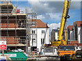
Construction works at The Old Tannery
New homes under construction by Bellway Homes.
Image: © Oast House Archive
Taken: 20 Apr 2012
0.07 miles
9
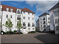
New Apartments by the Great Stour
A whole new community of residential blocks has been created in this part of town.
Image: © Des Blenkinsopp
Taken: 28 Aug 2011
0.07 miles