IMAGES TAKEN NEAR TO
Whitehall Road, RAMSGATE, CT12 6DE
Introduction
This page details the photographs taken nearby to Whitehall Road, CT12 6DE by members of the Geograph project.
The Geograph project started in 2005 with the aim of publishing, organising and preserving representative images for every square kilometre of Great Britain, Ireland and the Isle of Man.

There are currently over 7.5m images from over14,400 individuals and you can help contribute to the project by visiting https://www.geograph.org.uk
Image Map (Loading...)


Getting Data...Please wait
Leaflet Map data © OpenStreetMap
Images are licensed for reuse under creativecommons.org/licenses/by-sa/2.0
Notes
- Clicking on the map will re-center to the selected point.
- The higher the marker number, the further away the image location is from the centre of the postcode.
Image Listing (87 Images Found)
Images are licensed for reuse under creativecommons.org/licenses/by-sa/2.0
Image
Details
Distance
1
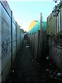
Path from Whitehall Road to St James' Avenue, Ramsgate
A public footpath, dating back to the 1800s. In the other direction it once led to St Lawrence's Church.
Image: © Christine Johnstone
Taken: 17 Feb 2022
0.04 miles
2
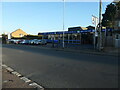
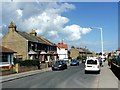
Whitehall Service Centre, Ramsgate
On the south side of Whitehall Road. Built on the route of the former Margate Branch of the South Eastern Railway.
Image: © Christine Johnstone
Taken: 17 Feb 2022
0.06 miles
3
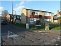
Housing on Hurst Grove, Ramsgate
The road runs north from Whitehall Road, on the line of the former Margate Branch of the South Eastern Railway.
Image: © Christine Johnstone
Taken: 17 Feb 2022
0.07 miles
4
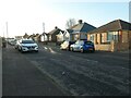
Bungalows on Kings Avenue, Newington
A suburb of Ramsgate. The road was laid out between 1896 and 1905, and the bungalows built between 1931 and 1936.
Image: © Christine Johnstone
Taken: 17 Feb 2022
0.13 miles
5
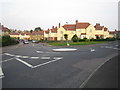
Ramsgate: Whitehall
Nixon Avenue goes down the hill to the left, Bradley Road is to the right.
Image: © Nigel Cox
Taken: 7 Jun 2007
0.13 miles
6
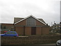
Disused church on Whitehall Road.
This small unknown church is on the junction of Whitehall Road (in front) and Newington Road (on the right). A board outside said that a planning application is being sort for a new housing development on the site.
Image: © David Anstiss
Taken: 6 Feb 2011
0.16 miles
8
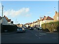
Nixon Avenue, Ramsgate
Running north from Whitehall Road. Both the avenue and the houses on it were built between 1918 and 1932.
Image: © Christine Johnstone
Taken: 17 Feb 2022
0.17 miles
9
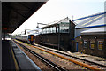
Signal box, Ramsgate station
This box is on the northern side of the lines. The unit standing between duties is a Class 375.
Image: © Dr Neil Clifton
Taken: 4 Jun 2010
0.18 miles
10
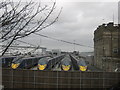
Awaiting Javelin Trains at Ramsgate
These four Javelin (high speed) trains are in a sidings yard, ready for use on the weekday for speeding to London.
As seen from Newington Road.
Image: © David Anstiss
Taken: 6 Feb 2011
0.18 miles