IMAGES TAKEN NEAR TO
Haine Road, RAMSGATE, CT12 5AE
Introduction
This page details the photographs taken nearby to Haine Road, CT12 5AE by members of the Geograph project.
The Geograph project started in 2005 with the aim of publishing, organising and preserving representative images for every square kilometre of Great Britain, Ireland and the Isle of Man.

There are currently over 7.5m images from over14,400 individuals and you can help contribute to the project by visiting https://www.geograph.org.uk
Image Map
Images are licensed for reuse under creativecommons.org/licenses/by-sa/2.0
Notes
- Clicking on the map will re-center to the selected point.
- The higher the marker number, the further away the image location is from the centre of the postcode.
Image Listing (13 Images Found)
Images are licensed for reuse under creativecommons.org/licenses/by-sa/2.0
Image
Details
Distance
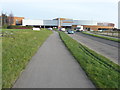
1
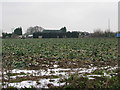
Haine Farm from the re-routed A256
A new road has been put in to take traffic away from the old A256 which passed Haine Farm on the western side. This road hasn't yet made it on to the 1:500000 map.
Image: © Nick Smith
Taken: 12 Jan 2010
0.11 miles
2
Sign to Rose Farm Shop
One of the original businesses is still trading next to the brand new superstores and warehouses on the edge of town retail area.
Image: © Des Blenkinsopp
Taken: 11 Aug 2017
0.12 miles
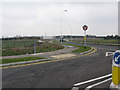
3
View along the new A256
A new road has been built to take traffic off the old A256, Haine Road, and it has adopted the A256 label.
Image: © Nick Smith
Taken: 12 Jan 2010
0.17 miles
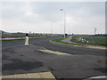
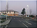
4
Looking N to Westwood Cross from the new A256
Image: © Nick Smith
Taken: 12 Jan 2010
0.21 miles
5
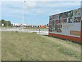
Information board about a new Sainsbury?s store
The board states that “your new Sainsbury’s Thanet opens winter 2014”.
Planning permission has been granted by Thanet District Council under application number F/TH/12/0781 for the "erection of retail superstore (use Class A1) (approx 14,400 sqm GEA), petrol filling station and public open space with associated landscaping, servicing, car parking, access and link road, together with outline application for 1 and 2 storey buildings for non-food retail, restaurants and or take away uses (Use Classes A1, A3-A5) with associated parking and open space, following demolition of existing buildings".
The location was described as “land and buildings south of Westwood Cross and between New Haine Road and Margate Road, Broadstairs”. It is an enormous site, some of which is hidden behind hoarding, beyond the roundabout, in this view.
This is how Image looks now it has been completed.
Image: © John Baker
Taken: 22 Jun 2014
0.22 miles
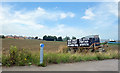
6
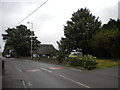
Farm shop on Haine Road near Westwood
The farm shop itself is the building with the very deep thatched roof; the exit from its car park is visible on the extreme right of the picture.
Image: © Richard Vince
Taken: 25 Aug 2012
0.22 miles
7

The vue cinema at Westwood Cross
The vue cinema and various eateries at Westwood Cross.
Image: © Philip Halling
Taken: 15 Sep 2012
0.22 miles

9
Travelodge at Westwood Cross
Taken from retail park car park
Image: © PAUL FARMER
Taken: 10 Jan 2009
0.23 miles
10
Sainsbury?s Thanet supermarket
Eighteen months ago there was only an Image
Image: © John Baker
Taken: 13 Jan 2016
0.23 miles