IMAGES TAKEN NEAR TO
Notley Terrace, Notley Street, CANTERBURY, CT1 1JS
Introduction
This page details the photographs taken nearby to Notley Terrace, Notley Street, CT1 1JS by members of the Geograph project.
The Geograph project started in 2005 with the aim of publishing, organising and preserving representative images for every square kilometre of Great Britain, Ireland and the Isle of Man.

There are currently over 7.5m images from over14,400 individuals and you can help contribute to the project by visiting https://www.geograph.org.uk
Image Map
Images are licensed for reuse under creativecommons.org/licenses/by-sa/2.0
Notes
- Clicking on the map will re-center to the selected point.
- The higher the marker number, the further away the image location is from the centre of the postcode.
Image Listing (318 Images Found)
Images are licensed for reuse under creativecommons.org/licenses/by-sa/2.0
Image
Details
Distance
1
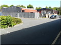
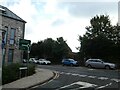
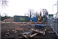
Former Dairy Crest depot, 57-61, Military Road
Canterbury City Council is considering whether or not to grant planning permission under application number CA//17/00648 for a “proposed two-storey building with accommodation in the roof space and three-storey building with basement comprising of 194 student rooms and associated facilities; amenity space; parking; access and areas of landscaping following demolition of existing buildings and structures”.
This is the back of the former depot from Notley Street (likewise this image of the Image) and this the view of the Image was taken from the front.
Image: © John Baker
Taken: 21 May 2017
0.02 miles
2
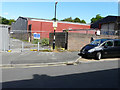
Former Dairy Crest depot, 57-61, Military Road
Canterbury City Council is considering whether or not to grant planning permission under application number CA//17/00648 for a “proposed two-storey building with accommodation in the roof space and three-storey building with basement comprising of 194 student rooms and associated facilities; amenity space; parking; access and areas of landscaping following demolition of existing buildings and structures”.
This view of the Image is the back of the depot in Notley Street (as is this) and this view of the Image was taken from the front.
Image: © John Baker
Taken: 21 May 2017
0.03 miles
3
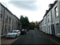
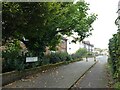
Looking along Notley Street towards Military Road
Image: © Basher Eyre
Taken: 23 Sep 2024
0.03 miles
4
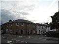
Notley Street at the junction of Military Road
Image: © David Howard
Taken: 31 Jul 2016
0.03 miles
5
Looking from Notley Street into Military Road
Image: © Basher Eyre
Taken: 23 Sep 2024
0.04 miles
6
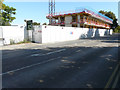
Student accommodation, 57-61, Military Road
Planning permission has been granted by Canterbury City Council under application number CA//17/00648 for a “proposed two-storey building with accommodation in the roof space and three-storey building with basement comprising of 194 student rooms and associated facilities; amenity space; parking; access and areas of landscaping following demolition of existing buildings and structures”.
The site used to be home to Image
Image: © John Baker
Taken: 25 Aug 2019
0.04 miles
7
Looking from Military Road into New Ruttington Lane
Image: © Basher Eyre
Taken: 23 Sep 2024
0.04 miles
8
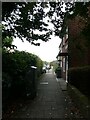
Path from Military Road to New Ruttington Lane
Image: © Basher Eyre
Taken: 23 Sep 2024
0.04 miles
9
Demolished Fastfood Restaurant
On the A28 Sturry Road, near the Asda / B and Q Warehouse Roundabout.
See http://www.geograph.org.uk/photo/1522374 before the destruction.
Image: © David Anstiss
Taken: 5 Dec 2009
0.05 miles
10
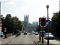
Canterbury, Military Road
Canterbury, Military Road, A28. Canterbury Cathedral visible in the distance.
Image: © Helmut Zozmann
Taken: 28 Jul 2011
0.05 miles