IMAGES TAKEN NEAR TO
Beach Drive, RAMSGATE, CT11 8FR

Introduction

This page details the photographs taken nearby to Beach Drive, CT11 8FR by members of the Geograph project.

The Geograph project started in 2005 with the aim of publishing, organising and preserving representative images for every square kilometre of Great Britain, Ireland and the Isle of Man.

There are currently over 7.5m images from over14,400 individuals and you can help contribute to the project by visiting https://www.geograph.org.uk

Image Map


Images are licensed for reuse under creativecommons.org/licenses/by-sa/2.0
Notes
  • Clicking on the map will re-center to the selected point.
  • The higher the marker number, the further away the image location is from the centre of the postcode.

Image Listing (392 Images Found)

Images are licensed for reuse under creativecommons.org/licenses/by-sa/2.0
  • ...
Image
Details
Distance
1
Royal Sands, Ramsgate
A housing development under East Cliff. The site was previously an amusement park and before that, a railway station. Historically, Ramsgate's harbour is royal, not its beach.
Image: © Christine Johnstone Taken: 16 Feb 2022
0.01 miles
2
Marina Esplanade at Ramsgate Tunnels, Ramsgate
Image: © Ian S Taken: 11 Feb 2020
0.01 miles
3
Royal Sands, Marina Esplanade
In April 2021, this was a Image
Image: © John Baker Taken: 5 Feb 2023
0.01 miles
4
Roundabout on Marina Esplanade
Image: © Oast House Archive Taken: 27 Jun 2009
0.01 miles
5
Disused railway tunnel at Ramsgate Harbour, Kent
In 1923 the two competing railway companies that served Kent were merged into the newly-formed Southern Railway. It soon set about sorting out the muddle of railways which it had been bequeathed on the Isle of Thanet. By building a short length of new line it created a loop around the Thanet coast, joining the two old systems together. As a result, the two former main line stations in Ramsgate were abandoned and a new one opened. One of these stations was the LC&DR's Ramsgate Harbour, which was approached by a mile long tunnel. The photo shows where the tunnel emerged onto the harbour front. From 1936 onwards a narrow-gauge railway used part of the railway tunnel, but eventually closed in 1965. See Image for a photograph of this railway taken in 1963.
Image: © Ron Strutt Taken: 1 Jul 2004
0.02 miles
6
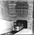
The Ramsgate Tunnel Narrow Gauge Railway
This railway used the old railway tunnel (see Image) and started in 1936 as the "World Scenic Railway". It did not run during the war when the railway tunnel and local caves were used for air-raid shelters - see http://www.undergroundkent.co.uk/ramsgate_tunnels.htm - and reopened after WW2. The photo was taken in July 1963 during a 6th-Form outing to Margate. This line was a narrow gauge electric railway (2ft?) with tram-style overhead pickup which ran through the old railway tunnel and then turned off to terminate in another part of the town. (The disused tunnels are marked on the largest scale maps you can access in this site.) The railway closed in 1965.
Image: © John Webb Taken: Unknown
0.02 miles
7
The entrance to Ramsgate Tunnels
Ramsgate Tunnels were reopened by HRH The Duke of Kent on 27 May 2014 so that people could explore them and experience how people sheltered and lived in them during the Second World War http://www.ramsgatetunnels.org/ These tunnels carried a railway line to Ramsgate Harbour station until 2 July 1926, when the station was closed. Planning permission was granted by Thanet District Council under application number F/TH/13/0980 for a “change of use of tunnels to provide visitor attraction (D2 use class) and to include alterations to/installation of metal entrance gates, creation of vehicular access, parking provision and landscaping work”.
Image: © John Baker Taken: 9 Nov 2014
0.02 miles
8
The entrance to Ramsgate Tunnels, Marina Esplanade
I wondered if the reason the tunnels were closed was to do with the work that is taking place to improve the cliff façade, prior to the start of the Royal Sands development. A more detailed explanation can be found in the description of Image However, having consulted the Ramsgate Tunnels’ website http://www.ramsgatetunnels.org/index.html I read that they are only open from Wednesdays to Sundays.
Image: © John Baker Taken: 15 Sep 2015
0.02 miles
9
Ramsgate Tunnels (entrance on Esplanade)
Image: © Colin Park Taken: 26 Sep 2019
0.02 miles
10
Ramsgate Tunnels
The tunnels originally brought the railway to Ramsgate Harbour station which was on the site now occupied by modern apartment blocks, and closed in 1926. In 1936 the former railway tunnel was converted to form the 'World Scenic Railway'. This used the old tunnel with a new link to a point close to Dumpton Park Station to provide railway passengers with a convenient link to to the beach, the new Ramsgate station being a considerable distance inland. The railway was a 2-foot gauge line, with overhead electric supply and two trains which shuttled between the two termini. The railway closed during the war when a network of additional tunnels was created to from air raid protection, and the concrete facade appears to date from this period. The scenic railway reopened after the war, finally closing in September 1965 due to the decline in traffic with the increase in car ownership. The tunnels reopened in the early 21st century as a tourist attraction featuring the various uses of the tunnels, particular the World War II period.
Image: © Alan Murray-Rust Taken: 4 Sep 2022
0.02 miles
  • ...