Disused railway tunnel at Ramsgate Harbour, Kent
Introduction
The photograph on this page of Disused railway tunnel at Ramsgate Harbour, Kent by Ron Strutt as part of the Geograph project.
The Geograph project started in 2005 with the aim of publishing, organising and preserving representative images for every square kilometre of Great Britain, Ireland and the Isle of Man.

There are currently over 7.5m images from over 14,400 individuals and you can help contribute to the project by visiting https://www.geograph.org.uk
Disused railway tunnel at Ramsgate Harbour, Kent
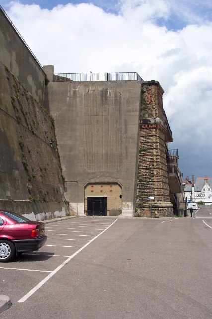
Image: © Ron Strutt Taken: 1 Jul 2004
In 1923 the two competing railway companies that served Kent were merged into the newly-formed Southern Railway. It soon set about sorting out the muddle of railways which it had been bequeathed on the Isle of Thanet. By building a short length of new line it created a loop around the Thanet coast, joining the two old systems together. As a result, the two former main line stations in Ramsgate were abandoned and a new one opened. One of these stations was the LC&DR's Ramsgate Harbour, which was approached by a mile long tunnel. The photo shows where the tunnel emerged onto the harbour front. From 1936 onwards a narrow-gauge railway used part of the railway tunnel, but eventually closed in 1965. See Image for a photograph of this railway taken in 1963.
Images are licensed for reuse under creativecommons.org/licenses/by-sa/2.0
Image Location
Latitude
51.334463
Longitude
1.426416