IMAGES TAKEN NEAR TO
St. Lawrence Avenue, RAMSGATE, CT11 0HP
Introduction
This page details the photographs taken nearby to St. Lawrence Avenue, CT11 0HP by members of the Geograph project.
The Geograph project started in 2005 with the aim of publishing, organising and preserving representative images for every square kilometre of Great Britain, Ireland and the Isle of Man.

There are currently over 7.5m images from over14,400 individuals and you can help contribute to the project by visiting https://www.geograph.org.uk
Image Map
Images are licensed for reuse under creativecommons.org/licenses/by-sa/2.0
Notes
- Clicking on the map will re-center to the selected point.
- The higher the marker number, the further away the image location is from the centre of the postcode.
Image Listing (103 Images Found)
Images are licensed for reuse under creativecommons.org/licenses/by-sa/2.0
Image
Details
Distance
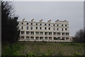
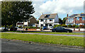
5
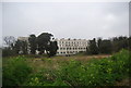
56, Royal Esplanade
Planning permission has been approved by Thanet District Council under application number FH/TH/21/0902 for the “erection of dormer window to rear elevation together with balcony and roof-lights to front elevation to facilitate loft conversion”.
Due to weeks of very little rain, the grass, either side of the path, had been bleached by the sun.
A similar view of Image after the modifications had been completed; due to a wet summer, the grass, either side of the path, was green.
Image: © John Baker
Taken: 14 Aug 2022
0.06 miles
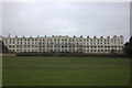
6
56, Royal Esplanade
A similar view of Image , when the house was undergoing modifications to its exterior.
Image: © John Baker
Taken: 20 Aug 2023
0.06 miles
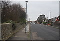
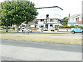
9
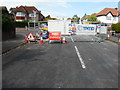
Road closure, St Mildreds Road
The banner reads ‘TPMD Improving Thanet’s ageing sewers’.
Southern Water is investing more than £30 million to upgrade Thanet’s ageing sewer network to help protect wildlife and the environment. Constructed by Victorian miners, the original sewer pipes were laid inside chalk tunnels known as adits.
Ground surveys and other works will continue this month [October 2018], with the main construction taking place towards the end of this year [2018]. The work is the second of three phases after Southern Water successfully carried out the first phase of works in 2014/15.
The new scheme is planned to be completed in early 2020 and will be carried out by TPMD, a team of three specialists – Terra Solutions, Pfeiffer and Matt Durbin Associates
https://www.carringtonwest.com/southern-water-invests-30-million-plus-to-upgrade-thanets-ageing-sewers/
Image: © John Baker
Taken: 2 May 2019
0.08 miles