IMAGES TAKEN NEAR TO
Fenemore Road, KENLEY, CR8 5GJ
Introduction
This page details the photographs taken nearby to Fenemore Road, CR8 5GJ by members of the Geograph project.
The Geograph project started in 2005 with the aim of publishing, organising and preserving representative images for every square kilometre of Great Britain, Ireland and the Isle of Man.

There are currently over 7.5m images from over14,400 individuals and you can help contribute to the project by visiting https://www.geograph.org.uk
Image Map
Images are licensed for reuse under creativecommons.org/licenses/by-sa/2.0
Notes
- Clicking on the map will re-center to the selected point.
- The higher the marker number, the further away the image location is from the centre of the postcode.
Image Listing (42 Images Found)
Images are licensed for reuse under creativecommons.org/licenses/by-sa/2.0
Image
Details
Distance
1
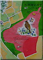
Map of Kenley Airfield, Surrey
Part of the map, showing the general layout of the airfield, within Kenley Common. Free public access to the green area, limited access to the light pink area (no access during flying activities).
The map is located on this board:
Image
Image: © Peter Trimming
Taken: 1 Apr 2010
0.03 miles
2
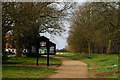
Bridleway to Kenley Common, Surrey
The sign marks the Corporation of London boundary. Much of Kenley Common was covered by RAF Kenley, the famous Battle of Britain sector station. The airfield is now used for gliders, but access is permitted outside the perimeter road.
http://www.raf.mod.uk/bob1940/11group.html
Map of Kenley airfield, displayed on the sign:
Image
Image: © Peter Trimming
Taken: 1 Apr 2010
0.03 miles
3
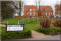
Egan Close, Kenley, Surrey
View towards some of the houses, in Egan Close, built on part of the RAF Kenley airfield. The roads are named as memorials to RAF pilots, based at RAF Kenley, who were killed in the Battle of Britain. Sergeant Edward James Egan (Hurricane Pilot) was killed on 17th September 1940*, aged 19.
http://www.raf.mod.uk/bob1940/roll.html
http://www.bbm.org.uk/Egan.htm
* Note: this is the date given on his gravestone inscription.
Image: © Peter Trimming
Taken: 1 Apr 2010
0.06 miles
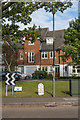
4
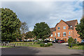
Egan Close
2006 development on the site of the former married quarters for personnel at RAF Kenley.
Image: © Ian Capper
Taken: 12 Oct 2018
0.06 miles
5
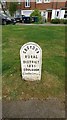
Old Boundary Marker
Parish Boundary Marker on the north side of the junction of Fenemore Road and Halton Road, Croydon. In raised lettering CROYDON / RURAL / DISTRICT / 1895 / COULSDON. See also https://www.geograph.org.uk/photo/5952975.
Milestone Society National ID: SY_CROY07pb
Image: © R Mills
Taken: 13 May 2020
0.08 miles
6
Egan Close/Halton Road
2006 development on the site of the former married quarters for personnel at RAF Kenley. In the foreground is a boundary marker for Coulsdon, dated 1895, part of what is now the London Borough of Croydon, whereas the houses themselves are in Kenley in Surrey.
Image: © Ian Capper
Taken: 12 Oct 2018
0.08 miles
7
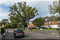
Buxton Lane
Buxton Lane near its junction with Halton Road and Egan Close, and just before it becomes Hayes Lane. The current route of Hayes Lane is off to the left; prior to the building of RAF Kenley in WWII, its route was straight on from here.
Image: © Ian Capper
Taken: 12 Oct 2018
0.08 miles
8
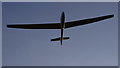
Coming Into Land
Having taken off from the grass of Kenley aerodrome, and completed one circuit, the Surrey Hills Gliding Club glider is coming into land on the runway. Take-off is via a winch, which is mounted on a lorry.
Image: © Peter Trimming
Taken: 17 Nov 2017
0.08 miles
9
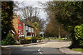
Buxton Lane, Kenley, Surrey
Around the bend, to the left, Buxton Lane becomes Hayes Lane. Straight on, is the bridleway to Kenley Common.
Image: © Peter Trimming
Taken: 1 Apr 2010
0.09 miles
10
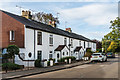
135 - 147 Buxton Lane
Late Victorian terrace, marked on the 1897 1:2,500 map as Coulsdon Cottages.
Image: © Ian Capper
Taken: 12 Oct 2018
0.09 miles