IMAGES TAKEN NEAR TO
Musgrove Close, PURLEY, CR8 4ES
Introduction
This page details the photographs taken nearby to Musgrove Close, CR8 4ES by members of the Geograph project.
The Geograph project started in 2005 with the aim of publishing, organising and preserving representative images for every square kilometre of Great Britain, Ireland and the Isle of Man.

There are currently over 7.5m images from over14,400 individuals and you can help contribute to the project by visiting https://www.geograph.org.uk
Image Map
Images are licensed for reuse under creativecommons.org/licenses/by-sa/2.0
Notes
- Clicking on the map will re-center to the selected point.
- The higher the marker number, the further away the image location is from the centre of the postcode.
Image Listing (60 Images Found)
Images are licensed for reuse under creativecommons.org/licenses/by-sa/2.0
Image
Details
Distance
1
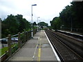
Reedham station
A branch line along the Chipstead Valley from the Brighton Main Line was first projected in 1884. This scheme failed to take off. The line from Purley East Junction to Kingswood & Burgh Heath was eventually opened on 2nd November 1897 as a single track and this was doubled during 1899. The line finally reached Tattenham Corner on 4th June 1901 - Derby Day. Reedham station opened as Reedham Halt on 1st March 1911. The station took its name from the nearby Reedham Home for Fatherless Children, opened in 1844. This in turn took its name from its founder, philanthropist the Rev. Andrew Reed - see http://en.wikipedia.org/wiki/Andrew_Reed_(clergyman) The purpose of Reedham Halt was to enable Chipstead Valley passengers to reach the orphanage and the new housing being built along the nearby main road. The Home was renamed Reedham Orphanage in 1904 and Reedham School in 1950. It closed in 1979, but the trust which ran it still occupies the original lodge (gatehouse) of the estate, just east of the station on the corner of Old Lodge Lane and Reedham Drive. The halt was renamed as a station on 5th July 1936. Reedham station is very close to the main Brighton line as can be seen here - the train in the distance is on the main line. In fact the line between Reedham and Coulsdon Town station, the next one to the south, runs alongside the main line almost the whole way.
Image: © Marathon
Taken: 18 Jul 2012
0.02 miles
2
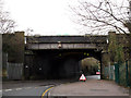
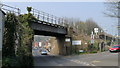
Railway over Old Lodge Lane (2)
This bridge carries the four tracks of the main London-Brighton line. The original brick arch has been extended with a steel girder bridge at each side. Tattenham Corner branch. The "road narrows" sign refers to utility works being carried out under the next bridge Image
Image: © Stephen Craven
Taken: 14 Feb 2013
0.04 miles
3
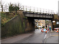
Railway over Old Lodge Lane (1)
This bridge carries the two tracks of the Tattenham Corner branch. Reedham station is off to the right. Utility works were being carried out under the bridge.
Image: © Stephen Craven
Taken: 14 Feb 2013
0.04 miles
4
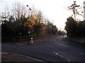
Road junction on Old Lodge Lane
Old Lodge Lane leads from Reedham left towards Kenley.
Hartley Down leads right towards Smitham and Coulsdon.
Image: © David Anstiss
Taken: 13 Nov 2011
0.05 miles
5
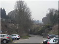
Railway Bridge Near Reedham Station
This is the bridge for the line which runs to Tattenham Corner. The bridge for the main line was directly behind me.
Image: © Peter Trimming
Taken: 3 Apr 2009
0.06 miles
6
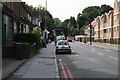
Old Lodge Lane, Purley, Surrey
This shows the northern end of Old Lodge Lane, looking south from where it joins Brighton Road. The apartment blocks on the Western side (right) are new (2006), but the property on the eastern side pre-dates the first world war. The bridge in the background carries the ex-SER Tattenham Corner branch, and Reedham Station is just up to the left at this point.
Image: © Dr Neil Clifton
Taken: 2 Aug 2007
0.06 miles
7
Reedham station: looking down the approach road
To the right, the line to Tattenham Corner leaving Reedham station; to the left, the fast lines to the North Downs gap and the South coast.
Image: © Christopher Hilton
Taken: 22 Mar 2011
0.06 miles
8
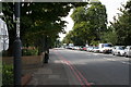
Brighton Road, Purley, Surrey (2)
Looking south from the Old Lodge Lane junction and showing the omnipresent queue of northbound vehicles, a feature which has got even worse since the Coulsdon Bypass was opened.
Image: © Dr Neil Clifton
Taken: 2 Aug 2007
0.08 miles
9
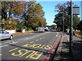
Brighton Road (A23). Looking north to Purley
This is one of the most congested stretches of the A23, between the junction of Old Lodge Lane and the north end of the Coulsdon Bypass. Taken from bus stop RJ.
Image: © Dr Neil Clifton
Taken: 17 Oct 2007
0.08 miles
10
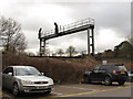
Signal gantry south of Purley
The gantry spans the four tracks of the London-Brighton main line. Viewed from the car park of Reedham station which is on a separate line.
Image: © Stephen Craven
Taken: 14 Feb 2013
0.09 miles