IMAGES TAKEN NEAR TO
Higher Drive, PURLEY, CR8 2HR
Introduction
This page details the photographs taken nearby to Higher Drive, CR8 2HR by members of the Geograph project.
The Geograph project started in 2005 with the aim of publishing, organising and preserving representative images for every square kilometre of Great Britain, Ireland and the Isle of Man.

There are currently over 7.5m images from over14,400 individuals and you can help contribute to the project by visiting https://www.geograph.org.uk
Image Map
Images are licensed for reuse under creativecommons.org/licenses/by-sa/2.0
Notes
- Clicking on the map will re-center to the selected point.
- The higher the marker number, the further away the image location is from the centre of the postcode.
Image Listing (29 Images Found)
Images are licensed for reuse under creativecommons.org/licenses/by-sa/2.0
Image
Details
Distance
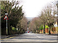
1
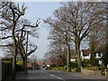
Street Scene, Higher Drive, Purley
The view looking down the hill, towards Purley.
Image: © Peter Trimming
Taken: 3 Apr 2009
0.01 miles
2
Road Junction in Purley
The junction of Woodland Way and Higher Drive.
Image: © Peter Trimming
Taken: 3 Apr 2009
0.04 miles
3
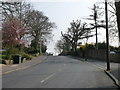
Street Scene, Higher Drive, Purley
The view looking up the hill.
Image: © Peter Trimming
Taken: 3 Apr 2009
0.07 miles
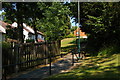
4
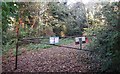
Entrance to Foxley Wood
As seen from Woodland Way.
A path leads through the woodland/nature reserve towards Kenley.
Image: © David Anstiss
Taken: 13 Nov 2011
0.08 miles
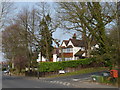
5
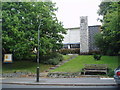
St. Barnabas Anglican Church, Higher Drive, Purley, Surrey
A modern and popular church serving an extensive suburban area
Image: © Dr Neil Clifton
Taken: 20 Sep 2005
0.10 miles
6
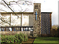
Belfry of St Barnabas church, Purley
The church dates from 1958. The bell is housed in a brick tower facing Higher Drive.
Image: © Stephen Craven
Taken: 14 Feb 2013
0.10 miles
7
Path from Aveling Close to Reedham Drive
Reedham Drive loops around to climb the steep side of the valley: this is one of several public footpaths that take more direct routes.
Image: © Christopher Hilton
Taken: 11 Jul 2013
0.10 miles
8

St.Barnabas Church, Higher Drive
An attractive modern building.
Image: © Peter Trimming
Taken: 3 Apr 2009
0.11 miles
9
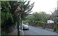
Looking down Bencom(b)e Road
The road name is shown in most maps as Bencombe Road, but the sign on the corner clearly gives it as Bencome.
The 15% gradient sign here and at the bottom of the hill Image have been put the wrong way round, as the sign warns of an uphill gradient.
Image: © Stephen Craven
Taken: 14 Feb 2013
0.11 miles
10
Bencombe Road - Steep Hill 15%
Bencombe Road, Reedham. 15% steep hill up sign, in the wrong place.
Image: © Adam Morse
Taken: 26 May 2009
0.11 miles