IMAGES TAKEN NEAR TO
Eskdale Gardens, PURLEY, CR8 1EZ
Introduction
This page details the photographs taken nearby to Eskdale Gardens, CR8 1EZ by members of the Geograph project.
The Geograph project started in 2005 with the aim of publishing, organising and preserving representative images for every square kilometre of Great Britain, Ireland and the Isle of Man.

There are currently over 7.5m images from over14,400 individuals and you can help contribute to the project by visiting https://www.geograph.org.uk
Image Map
Images are licensed for reuse under creativecommons.org/licenses/by-sa/2.0
Notes
- Clicking on the map will re-center to the selected point.
- The higher the marker number, the further away the image location is from the centre of the postcode.
Image Listing (32 Images Found)
Images are licensed for reuse under creativecommons.org/licenses/by-sa/2.0
Image
Details
Distance
1
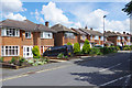
Honister Heights, Purley
The substantial houses here were built in the mid-1950s. This is the view from the junction with Eskdale Gardens.
Image: © Stephen McKay
Taken: 11 Jun 2019
0.04 miles
2
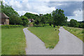
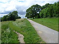
Riddlesdown Road
The path to the left leads to Eskdale Gardens and off the common; Riddlesdown Road eventually leads down to Godstone Road.
Image: © Stephen McKay
Taken: 11 Jun 2019
0.05 miles
3
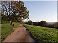
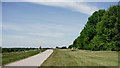
Bridleway path on Riddlesdown Down
This track (called Riddlesdown Road) leads through Riddlesdown to Whyteleafe Countryside Area down towards Tunnel Wood (in the background) and the A22 Godstone Road.
Image: © David Anstiss
Taken: 13 Nov 2011
0.08 miles
4
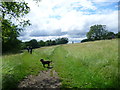
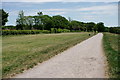
Summer on Riddlesdown
Riddlesdown is an area of chalk grassland and scrub on the side of the Caterham Valley with fine views north towards Croydon. It is owned by the City of London as one of several commons they own in this area. It is a popular spot with walkers.
Image: © Marathon
Taken: 4 Jul 2012
0.08 miles
5
Riddlesdown Road leading up to Riddlesdown
Riddlesdown is an area of chalk grassland and scrub on the side of the Caterham Valley with fine views north towards Croydon. It is owned by the City of London as one of several commons they own in this area. Although it is called Riddlesdown Road it can be clearly seen that the road here is little more than a path.
Image: © Marathon
Taken: 4 Jul 2012
0.10 miles
6
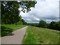
Riddledown Road
An information board advises that this was a Roman road and, more recently, a stagecoach route to Lewes until the A22 was constructed in the valley below.
Image: © Peter Trimming
Taken: 18 May 2020
0.11 miles
7
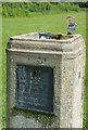
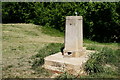
Drinking fountain on Riddlesdown
This seems an odd spot to find a drinking fountain, on the grass between Riddlesdown Road and Coombes Wood. Nevertheless it appears to be in working order. The plaque shows that it was provided by the Metropolitan Drinking Fountain and Cattle Trough Association and no doubt its presence here is a consequence of the land being owned and managed by the City of London Corporation.
Image: © Stephen McKay
Taken: 11 Jun 2019
0.13 miles
8
Riddlesdown Road on Riddlesdown
Riddlesdown is an area of chalk grassland and scrub on the side of the Caterham Valley with fine views north towards Croydon. It is owned by the City of London as one of several commons they own in this area. Although it is called Riddlesdown Road it can be clearly seen that the road here is little more than a path.
Image: © Marathon
Taken: 4 Jul 2012
0.13 miles
9
Riddledown Road
An information board advises that this was a Roman road and, more recently, a stagecoach route to Lewes until the A22 was constructed in the valley below.
Image: © Peter Trimming
Taken: 18 May 2020
0.13 miles
10
Riddlesdown Common
Water fountain (not working on the occasion of my visit), close to the woodland at the northern edge of the common.
Image: © Peter Trimming
Taken: 18 May 2020
0.13 miles