IMAGES TAKEN NEAR TO
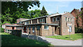
Buttermere Gardens, PURLEY, CR8 1EJ
Introduction
This page details the photographs taken nearby to Buttermere Gardens, CR8 1EJ by members of the Geograph project.
The Geograph project started in 2005 with the aim of publishing, organising and preserving representative images for every square kilometre of Great Britain, Ireland and the Isle of Man.

There are currently over 7.5m images from over14,400 individuals and you can help contribute to the project by visiting https://www.geograph.org.uk
Image Map
Images are licensed for reuse under creativecommons.org/licenses/by-sa/2.0
Notes
- Clicking on the map will re-center to the selected point.
- The higher the marker number, the further away the image location is from the centre of the postcode.
Image Listing (40 Images Found)
Images are licensed for reuse under creativecommons.org/licenses/by-sa/2.0
Image
Details
Distance
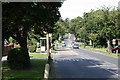
1
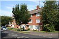
Mitchley Avenue, Sanderstead (5)
On the north side, just west of Copthorne Avenue, are these two small blocks of flats.
Image: © Dr Neil Clifton
Taken: 3 Aug 2007
0.08 miles
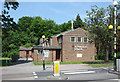
2
St Edmund's Church, Riddlesdown CR2
In A2022 Mitchley Avenue. Built 1955.
Image: © Philip Talmage
Taken: 4 Sep 2005
0.09 miles
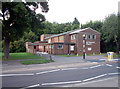
3
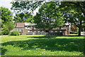
Mitchley Avenue at the junction of Buttermere Gardens
Image: © David Howard
Taken: 29 Oct 2012
0.09 miles
4
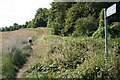
Public Footpath 190, Sanderstead, Surrey
From the south side of Mitchley Avenue (A2022) just opposite the end of Copthorne Rise, this footpath ascends, leading (according to the sign) to Derwent Drive in 250 yards. (Interestingly, footpath distances in this area have not been metricated)
Image: © Dr Neil Clifton
Taken: 3 Aug 2007
0.09 miles
5
St Edmund, Mitchley Avenue, Riddlesdown
Image: © John Salmon
Taken: 25 May 2010
0.09 miles
6

St Edmund, Mitchley Avenue, Riddlesdown - Chancel
Image: © John Salmon
Taken: 25 May 2010
0.09 miles
7
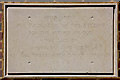
St Edmund, Mitchley Avenue, Riddlesdown - Foundation stone
Image: © John Salmon
Taken: 25 May 2010
0.10 miles
8
St Edmund, Mitchley Avenue, Riddlesdown
Image: © John Salmon
Taken: 25 May 2010
0.10 miles
9
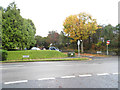
Mitchley Avenue, Sanderstead (6)
Looking westward from the junction with Copthorne Rise, Mitchley Avenue (the A2022) dips and then rises again to where it becomes Downs Court Road and starts the steep descent to Purley.
Image: © Dr Neil Clifton
Taken: 3 Aug 2007
0.10 miles
10
St Edmund, Mitchley Avenue, Riddlesdown
Image: © John Salmon
Taken: 25 May 2010
0.11 miles