IMAGES TAKEN NEAR TO
Mitchley Avenue, PURLEY, CR8 1EB
Introduction
This page details the photographs taken nearby to Mitchley Avenue, CR8 1EB by members of the Geograph project.
The Geograph project started in 2005 with the aim of publishing, organising and preserving representative images for every square kilometre of Great Britain, Ireland and the Isle of Man.

There are currently over 7.5m images from over14,400 individuals and you can help contribute to the project by visiting https://www.geograph.org.uk
Image Map
Images are licensed for reuse under creativecommons.org/licenses/by-sa/2.0
Notes
- Clicking on the map will re-center to the selected point.
- The higher the marker number, the further away the image location is from the centre of the postcode.
Image Listing (31 Images Found)
Images are licensed for reuse under creativecommons.org/licenses/by-sa/2.0
Image
Details
Distance
2
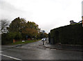
Downs Court Road at the junction of Riddlesdown Road
Image: © David Howard
Taken: 29 Oct 2012
0.05 miles
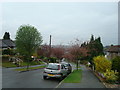
3
Mitchley Avenue
Mitchley Avenue by Ingleboro Driveto the right and Coombe Wood Hill to the left
Image: © Shaun Ferguson
Taken: 26 Jun 2012
0.08 miles
4
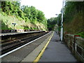
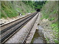
Looking towards Riddlesdown Tunnel from Riddlesdown station
The line between Croydon and East Grinstead was opened on 10th March 1884 by the London, Brighton & South Coast Railway and the South Eastern Railway. This view is from the up platform at Riddlesdown station towards Riddlesdown Tunnel.
Image: © Marathon
Taken: 4 Jul 2012
0.11 miles
5
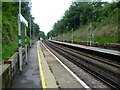
Riddlesdown Tunnel from Riddlesdown station
The line between Croydon and East Grinstead was opened on 10th March 1884 by the London, Brighton & South Coast Railway and the South Eastern Railway. This view is from the end of the platform at Riddlesdown station to Riddlesdown Tunnel.
Image: © Marathon
Taken: 4 Jul 2012
0.11 miles
7
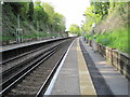
Riddlesdown railway station, Greater London
Opened in 1927 by the Southern Railway on what is now the line from Croydon to Uckfield and East Grinstead. View north towards Sanderstead and Croydon.
Image: © Nigel Thompson
Taken: 16 May 2013
0.12 miles
8
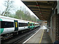
Riddlesdown station
The line between Croydon and East Grinstead was opened on 10th March 1884 by the London, Brighton & South Coast Railway and the South Eastern Railway. This view is from the up platform looking in the direction of Sanderstead and East Croydon.
Image: © Marathon
Taken: 4 Jul 2012
0.12 miles
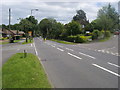
9
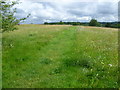
The way on to Riddlesdown
Riddlesdown is an area of chalk grassland and scrub on the side of the Caterham Valley with fine views north towards Croydon. It is owned by the City of London as one of several commons they own in this area. The yellow flower en masse in the grass here is yellow rattle, so called because of its loose, rattling seeds when its fruit is ripe.
Image: © Marathon
Taken: 4 Jul 2012
0.13 miles
10
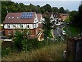
Overlooking Lower Barn Road, Riddlesdown
View looking down on Lower Barn Road by Riddlesdown station, from the end coach of a Victoria to East Grinstead train. The train has stopped at Riddlesdown but because it is longer than the platform this coach, the last of 12, is some way short of the station.
Image: © Ed of the South
Taken: 29 Aug 2014
0.13 miles