IMAGES TAKEN NEAR TO
Quadrant Road, THORNTON HEATH, CR7 7DB
Introduction
This page details the photographs taken nearby to Quadrant Road, CR7 7DB by members of the Geograph project.
The Geograph project started in 2005 with the aim of publishing, organising and preserving representative images for every square kilometre of Great Britain, Ireland and the Isle of Man.

There are currently over 7.5m images from over14,400 individuals and you can help contribute to the project by visiting https://www.geograph.org.uk
Image Map
Images are licensed for reuse under creativecommons.org/licenses/by-sa/2.0
Notes
- Clicking on the map will re-center to the selected point.
- The higher the marker number, the further away the image location is from the centre of the postcode.
Image Listing (123 Images Found)
Images are licensed for reuse under creativecommons.org/licenses/by-sa/2.0
Image
Details
Distance
1
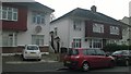
Flats on Quadrant Road, Thornton Heath
What appear to be semi-detached houses are actually purpose-built flats: each "half" of the building comprises two flats, one above the other, each with its own front door at the side of the building.
Image: © Christopher Hilton
Taken: 9 May 2016
0.01 miles
2
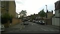
Quadrant Road, Thornton Heath
At the corner of the road in the distance, what appear to be semi-detached houses are actually purpose-built flats: each "half" of the building comprises two flats, one above the other, each with its own front door at the side of the building.
Image: © Christopher Hilton
Taken: 9 May 2016
0.02 miles
3
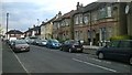
South end of Richmond Road, Thornton Heath
Image: © Christopher Hilton
Taken: 9 May 2016
0.05 miles
4
Norbury Brook: looking downstream at Quadrant Road
See Image for another downstream view from this point, and Image for the view upstream from Quadrant Road.
Downstream from here the brook flows into Thornton Heath Recreation Ground, as shown on Image
Image: © Christopher Hilton
Taken: 7 Nov 2011
0.07 miles
5

Norbury Brook: looking downstream at Quadrant Road
See Image for another downstream view from this point, and Image for the view upstream from Quadrant Road.
Downstream from here the brook flows into Thornton Heath Recreation Ground, as shown on Image
Image: © Christopher Hilton
Taken: 7 Nov 2011
0.07 miles
6

Norbury Brook: looking upstream at Quadrant Road
See also Image and Image for the view downstream from this crossing.
The next crossing upstream is Brigstock Road: see Image for the view downstream from there.
The building top left is the church hall of St Andrew's Roman Catholic Church, around the corner on Brook Road.
Image: © Christopher Hilton
Taken: 7 Nov 2011
0.08 miles
7
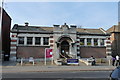
Thornton Heath Library
The Fire Station used to stand to the left of the Library, but was demolished many years ago.
Image: © Peter Trimming
Taken: 20 Mar 2009
0.09 miles
8
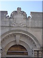
Thornton Heath Library
The main entrance to the Edwardian building, taken during building works in 2010 which improved access to the old building but at the cost of adding a much-disliked modern concrete box entrance to the side of this. The crowning glory of the new entrance is the word "Library" in vast, disproportionate concrete letters. I dislike it so much I'll leave it to someone else to record that part of the building.
Image: © Christopher Hilton
Taken: 17 May 2010
0.09 miles
9
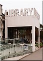
Thornton Heath Public Library extension
Built in 2009/2010 to designs prepared by FAT Architects.
Image: © Jim Osley
Taken: 23 Oct 2015
0.10 miles
10
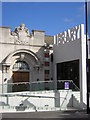
Thornton Heath Library
The Edwardian building and the unloved extension that opened in 2010.
Image: © Christopher Hilton
Taken: 5 Aug 2010
0.11 miles