IMAGES TAKEN NEAR TO
Sandringham Road, THORNTON HEATH, CR7 7AX
Introduction
This page details the photographs taken nearby to Sandringham Road, CR7 7AX by members of the Geograph project.
The Geograph project started in 2005 with the aim of publishing, organising and preserving representative images for every square kilometre of Great Britain, Ireland and the Isle of Man.

There are currently over 7.5m images from over14,400 individuals and you can help contribute to the project by visiting https://www.geograph.org.uk
Image Map
Images are licensed for reuse under creativecommons.org/licenses/by-sa/2.0
Notes
- Clicking on the map will re-center to the selected point.
- The higher the marker number, the further away the image location is from the centre of the postcode.
Image Listing (80 Images Found)
Images are licensed for reuse under creativecommons.org/licenses/by-sa/2.0
Image
Details
Distance
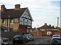
1
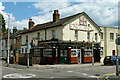
The Pawsons Arms
Becoming a bit of a rarity around here - a pub that hasn't closed! The sign shows a coat of arms presumably belong to a Mr Pawson at some time, but brief research failed to find out who he was.
Image: © Robin Webster
Taken: 29 Jun 2011
0.05 miles
2
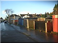
Garages, Sandringham Road, Croydon
An awkward right-angle where the road changes name, and the absence of any houses along this side of the road, suggest that Sandringham Road here marks the edge of one block of housing development and the start of another. The garages apparently serve houses facing onto Swain Road.
Image: © Christopher Hilton
Taken: 28 Jan 2014
0.05 miles
3
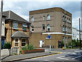
Flats, corner of Pawson's Road and Pitt Road
Architecture and decoration could be described as odd. In late Victorian and Edwardian times it was the Gladstone pub.
Image: © Robin Webster
Taken: 29 Jun 2011
0.05 miles
4
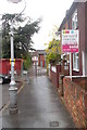
Path from Palmerston Road to Marion Road, Thornton Heath
Image: © Christopher Hilton
Taken: 24 May 2013
0.08 miles
5
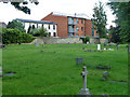
Houses and flats on Mayo Road
A rear view from Queen's Road Cemetery.
Image: © Robin Webster
Taken: 29 Jun 2011
0.11 miles
6
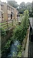
Treetops Court and the Norbury Brook
Treetops Court is a small development off Swain Road, shoehorned in between buildings: the line of the Norbury Brook allows a route in, between the houses of Swain Road, and access to the houses from the car park is over little footbridges.
This is the view upstream; for that downstream from a similar point, see Image
Image: © Christopher Hilton
Taken: 10 Sep 2013
0.12 miles
7
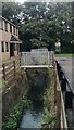
The Norbury Brook in front of Treetops Court
Treetops Court is a small development off Swain Road, shoehorned in between buildings: the line of the Norbury Brook allows a route in, between the houses of Swain Road, and access to the houses from the car park is over little footbridges. Behind the further footbridge the brook emerges from a culvert that stretches several hundred yards to Selhurst station.
This is the view upstream; for that downstream from a similar point, see Image
Image: © Christopher Hilton
Taken: 10 Sep 2013
0.12 miles
8
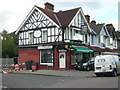
Former St David's Stores, Kynaston Road, Thornton Heath
Image: © Christopher Hilton
Taken: 26 Sep 2011
0.13 miles
9
Former St David's Stores, Kynaston Road, Thornton Heath
In the background, the maintenance site for Coughlan's bakeries, an institution in Croydon and the surrounding areas.
Image: © Christopher Hilton
Taken: 23 Sep 2011
0.13 miles
10
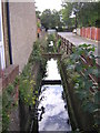
Swain Road: looking upstream at the crossing of the Norbury Brook
A new development, Treetops Court, has been inserted into the street pattern here: its access road runs alongside the brook, opening it up, and one reaches its houses over small bridges.
For the view downstream towards this point, see Image
The view downstream at the Swain Road crossing, behind the photographer's back, can be seen in Image
Image: © Christopher Hilton
Taken: 13 Sep 2011
0.13 miles