
IMAGES TAKEN NEAR TO
Greenfield Link, COULSDON, CR5 2SW
Introduction
This page details the photographs taken nearby to Greenfield Link, CR5 2SW by members of the Geograph project.
The Geograph project started in 2005 with the aim of publishing, organising and preserving representative images for every square kilometre of Great Britain, Ireland and the Isle of Man.

There are currently over 7.5m images from over14,400 individuals and you can help contribute to the project by visiting https://www.geograph.org.uk
Image Map
Images are licensed for reuse under creativecommons.org/licenses/by-sa/2.0
Notes
- Clicking on the map will re-center to the selected point.
- The higher the marker number, the further away the image location is from the centre of the postcode.
Image Listing (122 Images Found)
Images are licensed for reuse under creativecommons.org/licenses/by-sa/2.0
Image
Details
Distance
1
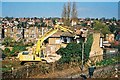
Demolition of 8, Windermere Road, Coulsdon, Surrey
This house along with fifteen other perfectly good semi-detached houses, was demolished to make way for the Coulsdon Inner Relief Road (A 23). The photograph was taken from the Up platform of Smitham station.
Image: © Dr Neil Clifton
Taken: 4 Apr 2003
0.10 miles
2
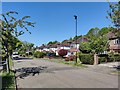
Byron Avenue
Residential road of Coulsdon.
Image: © James Emmans
Taken: 6 May 2020
0.10 miles
3
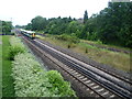
Site of Coulsdon North station
In this view from the footbridge near Coulsdon Town station, the fast lines are nearer the camera and the slow lines are beyond. Coulsdon North station was located here, straddling all four tracks. It was opened as 'Stoats Nest and Cane Hill' in 1899 and went through several different names before being closed as Coulsdon North in 1983. It is only a very short walk to Smitham (now Coulsdon Town) station (see http://www.geograph.ie/photo/3045242 ) and this was one of the reasons it was closed. More information about Coulsdon North station can be found at http://en.wikipedia.org/wiki/Coulsdon_North_railway_station and http://www.disused-stations.org.uk/c/coulsdon_north/index.shtml
Image: © Marathon
Taken: 18 Jul 2012
0.14 miles
4
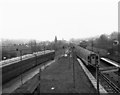
View north from Coulsdon North station
An empty 4-SUB unit occupies Platform 2, while an express unit from the coast speeds northwards through the disused Platform 3. Coulsdon North signal box was still there when this photograph was taken in 1981.
Image: © Dr Neil Clifton
Taken: 22 Feb 1981
0.14 miles
5
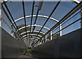
Walkway
Pedestrian walkway over the London-Brighton railway line at Smitham
Image: © Kurseong Carl
Taken: 24 May 2011
0.14 miles
6
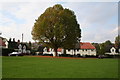
Stoats Nest Village (3)
This splendid plane tree which stands on the south-west corner of the green, is probably quite a bit older than the houses
Image: © Dr Neil Clifton
Taken: 15 Oct 2007
0.15 miles
7
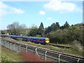
First Capital Connect train at Coulsdon
Image: © Stacey Harris
Taken: 11 Apr 2010
0.15 miles
8
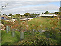
Site of the former Coulsdon North Station
Nothing to say really. I was tempted to classify this one as 'vandalism (official)'
Image: © Dr Neil Clifton
Taken: 18 Oct 2009
0.15 miles
9
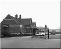
The last day at Coulsdon North (1)
This is the pleasant ex-LBSCR station at Coulsdon North, photographed on its last day of operation, 30 September 1983.
Image: © Dr Neil Clifton
Taken: 30 Sep 1983
0.16 miles
10

Up Train
Passing the footbridge by Smitham Station
Image: © Kurseong Carl
Taken: 18 Jun 2011
0.16 miles