IMAGES TAKEN NEAR TO
Station Approach Road, COULSDON, CR5 2FH
Introduction
This page details the photographs taken nearby to Station Approach Road, CR5 2FH by members of the Geograph project.
The Geograph project started in 2005 with the aim of publishing, organising and preserving representative images for every square kilometre of Great Britain, Ireland and the Isle of Man.

There are currently over 7.5m images from over14,400 individuals and you can help contribute to the project by visiting https://www.geograph.org.uk
Image Map (Loading...)


Getting Data...Please wait
Leaflet Map data © OpenStreetMap
Images are licensed for reuse under creativecommons.org/licenses/by-sa/2.0
Notes
- Clicking on the map will re-center to the selected point.
- The higher the marker number, the further away the image location is from the centre of the postcode.
Image Listing (330 Images Found)
Images are licensed for reuse under creativecommons.org/licenses/by-sa/2.0
Image
Details
Distance
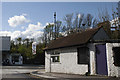
1
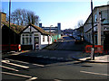
Coulsdon: Smitham station approach
The small building on the left was originally a coal office, then when coal traffic ceased it became a mini-cab office for many years, but was then deserted altogether. Now it has re-opened as the 'Iron Inn', a washing, ironing and dry-cleaning facility which also offers collection and delivery - a boon to the single businessman with limited time at his disposal.
On the other side of the approach is an empty and disused car showroom, where Toyotas were sold until recently.
Image: © Dr Neil Clifton
Taken: 1 Mar 2010
0.00 miles
2
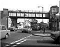
Coulsdon: Brighton Road
Looking north. The overbridge carries the ex-SER Tattenham Corner branch. The bus, on Route 166, is a standee single-decker of the SMS type. On these buses you paid your fare into a machine to operate a turnstile. They were universally unpopular, being regarded as cattle trucks, and only lasted a couple of years.
Image: © Dr Neil Clifton
Taken: 23 Sep 1972
0.01 miles
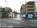
3
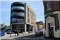
Coulsdon: Trinity Square
A recently added block with a Pizza Express on the ground floor. On the left, a road called Leaden Hill (? why) goes up to Coulsdon Town station. At the right, a road called Station Approach Road does not go anywhere, certainly not to a station. Just another way of keeping the public (mis)informed.
Image: © Dr Neil Clifton
Taken: 10 May 2017
0.01 miles
5
Small business
Small retail outlet at the corner of Station Approach & Brighton Road
Image: © Kurseong Carl
Taken: 29 Apr 2012
0.01 miles
6

Coulsdon: Brighton Road in 1972
Looking south
Image: © Dr Neil Clifton
Taken: 23 Sep 1972
0.01 miles
7
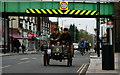
London - Brighton Veteran Car Run 2011
No.60, a New Orleans, dating from 1900, seen on the Brighton Road, Coulsdon.
Image: © Peter Trimming
Taken: 6 Nov 2011
0.01 miles
8
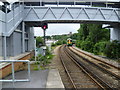
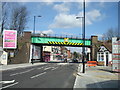
Cousdon Town (formerly Smitham) station
A branch line along the Chipstead Valley from the Brighton Main Line was first projected in 1884. This scheme failed to take off. The line from Purley East Junction to Kingswood & Burgh Heath was eventually opened on 2nd November 1897 as a single track and this was doubled during 1899. The line finally reached Tattenham Corner on 4th June 1901 - Derby Day. Smitham station was opened on 1st January 1904, and briefly closed during the First World War. It lies on a sharp curve, where the line swings away westwards from the Brighton Main Line, and is immediately adjacent to the closed Coulsdon North station on the Main Line, whose passenger traffic was diverted here when the latter closed on 3rd October 1983. The Coulsdon relief road, opened in December 2006 as part of the A23, passes underneath the station and meant that some changes to the platform access routes was required. Consequently, no direct access to the London-bound platform now exists; access is only via the other platform and a new footbridge or a lift. A new station building on the down side of the line, and a standard-pattern accessible footbridge were opened in 2010. The footbridge at the Tattenham Corner end of the platform is seen here. The church in the distance is St Andrew, Coulsdon.
The Department for Transport requested that, following lobbying by Croydon Council, the train company look into a better name for the station, as Smitham was no longer used as the name of the local area, and the station was close to the centre of Coulsdon. The name chosen, after an exercise in local democracy, was Coulsdon Town. The change took place on Sunday 22nd May 2011.
Image: © Marathon
Taken: 18 Jul 2012
0.01 miles
9
Coulsdon: New building
This recently-unveiled building has been given the name 'Trinity Square'. Why - who knows? I believe it contains both residential and office accommodation.
On the left is seen the former coal office which has had many uses over the last few years, the last being as the 'Vape Pit' to encourage the habit (by no means is it non-addictive) of 'Vaping', which personally I regard as a menace. But commercial interests are trying to establish this, now that smoking has thankfully declined. I am glad to see that it appears to have closed.
Image: © Dr Neil Clifton
Taken: 24 Apr 2015
0.01 miles
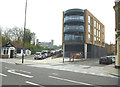
10
Coulsdon: New construction
Looking up Leaden Hill (the new name for the approach road to *Coulsdon Town station), a very large building, which appears to be speculative commercial property, is under construction on the right-hand side.
*recently renamed from Smitham.
Image: © Dr Neil Clifton
Taken: 4 Jan 2014
0.01 miles