IMAGES TAKEN NEAR TO
Leaden Hill, COULSDON, CR5 2BQ
Introduction
This page details the photographs taken nearby to Leaden Hill, CR5 2BQ by members of the Geograph project.
The Geograph project started in 2005 with the aim of publishing, organising and preserving representative images for every square kilometre of Great Britain, Ireland and the Isle of Man.

There are currently over 7.5m images from over14,400 individuals and you can help contribute to the project by visiting https://www.geograph.org.uk
Image Map (Loading...)


Getting Data...Please wait
Leaflet Map data © OpenStreetMap
Images are licensed for reuse under creativecommons.org/licenses/by-sa/2.0
Notes
- Clicking on the map will re-center to the selected point.
- The higher the marker number, the further away the image location is from the centre of the postcode.
Image Listing (278 Images Found)
Images are licensed for reuse under creativecommons.org/licenses/by-sa/2.0
Image
Details
Distance
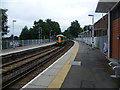
1
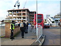
Coulsdon Town station
For a time during engineering works, the Gatwick Express service was provided by a non-stop service to Coulsdon Town, followed by a bus from there to the airport.
Image: © Dr Neil Clifton
Taken: 12 Jan 2014
0.01 miles
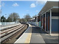
2
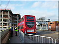
Coulsdon Town railway station
Opened in 1904 by the South Eastern & Chatham Railway on the branch line from Purley to Tattenham Corner. View north east towards Reedham and Purley. This station was called Smitham until 2010.
Image: © Nigel Thompson
Taken: 17 May 2012
0.01 miles
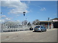
4
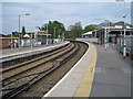
Coulsdon Town (formerly Smitham) station
A branch line along the Chipstead valley from the Brighton Main Line was first projected in 1884. This scheme failed to take off. The line from Purley East Junction to Kingswood & Burgh Heath was eventually opened on 2nd November 1897 as a single track and this was doubled during 1899. The line finally reached Tattenham Corner on 4th June 1901 - Derby Day. Smitham station was opened on 1st January 1904, and briefly closed during the First World War. It lies on a sharp curve, where the line swings away westwards from the Brighton Main Line, and is immediately adjacent to the closed Coulsdon North station on the Main Line, whose passenger traffic was diverted here when the latter closed on 3rd October 1983. The Coulsdon relief road, opened in December 2006 as part of the A23, passes underneath the station and meant that some changes to the platform access routes was required. Consequently, no direct access to the London-bound platform now exists; access is only via the other platform and a new footbridge or a lift. A new station building on the down side of the line (seen here), and a standard-pattern accessible footbridge were opened in 2010.
The Department for Transport requested that, following lobbying by Croydon Council, the train company look into a better name for the station, as Smitham was no longer used as the name of the local area, and the station was close to the centre of Coulsdon. The name chosen, after an exercise in local democracy, was Coulsdon Town. The change took place on Sunday 22nd May 2011.
Image: © Marathon
Taken: 18 Jul 2012
0.02 miles
6
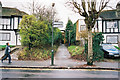
Passage to Smitham station
This ran between Nos 8 and 10 Windermere Road. See Image
Image: © Dr Neil Clifton
Taken: 27 Dec 2002
0.02 miles
8
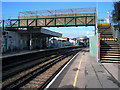
Smitham station
Showing the temporary footbridge erected when the subway was closed.
Image: © Dr Neil Clifton
Taken: 30 Aug 2006
0.02 miles
9
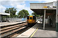
Smitham station
Class 455 unit 455 825 waits to leave with a train to Tattenham Corner. The temporary footbridge has been removed, replaced by a permanent structure at the other end of the platforms.
Image: © Dr Neil Clifton
Taken: 21 Jun 2007
0.02 miles