IMAGES TAKEN NEAR TO
Church Road, MITCHAM, CR4 3TD
Introduction
This page details the photographs taken nearby to Church Road, CR4 3TD by members of the Geograph project.
The Geograph project started in 2005 with the aim of publishing, organising and preserving representative images for every square kilometre of Great Britain, Ireland and the Isle of Man.

There are currently over 7.5m images from over14,400 individuals and you can help contribute to the project by visiting https://www.geograph.org.uk
Image Map
Images are licensed for reuse under creativecommons.org/licenses/by-sa/2.0
Notes
- Clicking on the map will re-center to the selected point.
- The higher the marker number, the further away the image location is from the centre of the postcode.
Image Listing (53 Images Found)
Images are licensed for reuse under creativecommons.org/licenses/by-sa/2.0
Image
Details
Distance
1
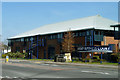
Boundary Business Court
One of two similar buildings fronting Church Road. They feature prominent spiral fire escapes.
Image: © Robin Webster
Taken: 1 Apr 2012
0.04 miles
2
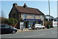
The Wheatsheaf
Not a pub but 'Your local convenience store'. Although not looking much like an ex-pub, reference to old maps shows that there was indeed a pub here, in the same block as houses to the left. These have now been demolished. Presumably the pub was called The Wheatsheaf.
Image: © Robin Webster
Taken: 1 Apr 2012
0.06 miles
4
Bricked up building, Mitcham churchyard
By one of the churchyard entrances, all windows and doors, except one vehicle sized doorway in the left-hand end, are bricked up. The wall facing the street is plain.
Image: © Robin Webster
Taken: 1 Apr 2012
0.09 miles
5
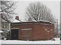
Mitcham churchyard: former mortuary
The building looked to me to be out of keeping with churchyard buildings and possibly the right size and style for a London Electricity Board substation of the 1930s (or thereabouts). However I have since been informed by someone who used to live nearby that it was the mortuary including "slabs where the bodies were laid out for inspection after death". There was a separate cemetery chapel, which has now been demolished, and the mortuary is now disused with the windows bricked up.
Image: © Stephen Craven
Taken: 13 Jan 2010
0.09 miles
6
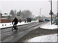
Church Road / Miles Road, Mitcham
The cyclist is coming out of Miles Road into Church Road. This is at the north-west corner of Mitcham parish churchyard.
Image: © Stephen Craven
Taken: 13 Jan 2010
0.09 miles

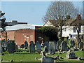
8
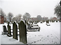
Mitcham churchyard: graves (2)
The northern part of the churchyard, looking east.
Image: © Stephen Craven
Taken: 13 Jan 2010
0.10 miles
9
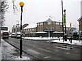
Zebra crossing on Church Road, Mitcham
The side road on the opposite side is Chantry Way. The bus is on route 200 to Mitcham.
Image: © Stephen Craven
Taken: 13 Jan 2010
0.11 miles
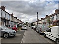
10
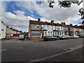
Miles Road
Victorian terrace housing.
Image: © James Emmans
Taken: 11 May 2020
0.11 miles