IMAGES TAKEN NEAR TO
Veals Mead, MITCHAM, CR4 3SB
Introduction
This page details the photographs taken nearby to Veals Mead, CR4 3SB by members of the Geograph project.
The Geograph project started in 2005 with the aim of publishing, organising and preserving representative images for every square kilometre of Great Britain, Ireland and the Isle of Man.

There are currently over 7.5m images from over14,400 individuals and you can help contribute to the project by visiting https://www.geograph.org.uk
Image Map (Loading...)


Getting Data...Please wait
Leaflet Map data © OpenStreetMap
Images are licensed for reuse under creativecommons.org/licenses/by-sa/2.0
Notes
- Clicking on the map will re-center to the selected point.
- The higher the marker number, the further away the image location is from the centre of the postcode.
Image Listing (8 Images Found)
Images are licensed for reuse under creativecommons.org/licenses/by-sa/2.0
Image
Details
Distance
1
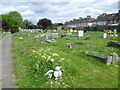
London Road Cemetery
London Road Cemetery opened in April 1929 and is owned and maintained by Merton Council. The houses on the right are in Hawkes Road.
Image: © Marathon
Taken: 16 May 2012
0.13 miles
2
London Road Cemetery
London Road Cemetery opened in April 1929 and is owned and maintained by Merton Council. The cemetery chapel can be seen in the distance.
Image: © Marathon
Taken: 16 May 2012
0.15 miles
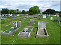
3

War graves in London Road Cemetery
London Road Cemetery opened in April 1929 and is owned and maintained by Merton Council. There are 66 Second World War burials in this special service plot towards the western end. The plot also contains four non-war burials, those of three men of the Auxiliary Fire Service and one civilian ex-serviceman.
Image: © Marathon
Taken: 16 May 2012
0.19 miles
4

War graves in London Road Cemetery
London Road Cemetery opened in April 1929 and is owned and maintained by Merton Council. There are 66 Second World War burials in this special service plot towards the western end. The plot also contains four non-war burials, those of three men of the Auxiliary Fire Service and one civilian ex-serviceman. As always the graves are beautifully maintained.
Image: © Marathon
Taken: 16 May 2012
0.19 miles
5
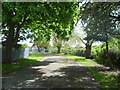
Lane round Tamworth Farm Allotments
This lane runs in a semi-circle around Tamworth Farm Allotments, to and from London Road, Mitcham. The allotments are to the left here whereas to the right are what appear to be former allotments which are now very overgrown and attract some rubbish dumping. There seems to be no vehicle access to the lane.
Image: © Marathon
Taken: 16 May 2012
0.21 miles
6
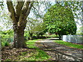
Lane behind Tamworth Farm Allotments
This lane runs in a semi-circle around Tamworth Farm Allotments, to and from London Road, Mitcham. The allotments are to the right here whereas to the left are what appear to be former allotments which are now very overgrown and attract some rubbish dumping. There seems to be no vehicle access to the lane.
Image: © Marathon
Taken: 16 May 2012
0.22 miles
7
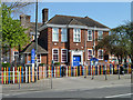
Liberty Primary School
On Western Road, Mitcham.
Image: © Robin Webster
Taken: 1 Apr 2012
0.24 miles
8
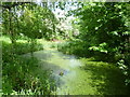
Pond in Myrna Close Valley
The railway line from Wimbledon to West Croydon opened in 1855. In 1868, the Tooting, Wimbledon & Sutton line was opened, and a branch from Tooting via Merton Abbey to the Wimbledon to West Croydon line at Merton Park was also opened. The last passenger train on the Tooting to Merton Park line ran on 2nd March 1929, and after that only steam freight trains and the occasional excursion used the line. The junction at the Tooting end was severed in 1934 so that the line was worked as a long siding from Merton Park. All traffic finally ceased in May 1975 and the tracks between Merton Park and Tooting were removed soon afterwards. Part of the old trackbed has been preserved here and turned into a linear park, with a stream and ponds, as well as a path throughout. The park is known as Myrna Close Valley. Further west at Merton Park another section of the old line has been preserved and is known as Merton Park Green Walks - see http://www.geograph.org.uk/photo/5289871
Image: © Marathon
Taken: 16 May 2012
0.25 miles