IMAGES TAKEN NEAR TO
Rose Avenue, MITCHAM, CR4 3JS
Introduction
This page details the photographs taken nearby to Rose Avenue, CR4 3JS by members of the Geograph project.
The Geograph project started in 2005 with the aim of publishing, organising and preserving representative images for every square kilometre of Great Britain, Ireland and the Isle of Man.

There are currently over 7.5m images from over14,400 individuals and you can help contribute to the project by visiting https://www.geograph.org.uk
Image Map (Loading...)


Getting Data...Please wait
Leaflet Map data © OpenStreetMap
Images are licensed for reuse under creativecommons.org/licenses/by-sa/2.0
Notes
- Clicking on the map will re-center to the selected point.
- The higher the marker number, the further away the image location is from the centre of the postcode.
Image Listing (40 Images Found)
Images are licensed for reuse under creativecommons.org/licenses/by-sa/2.0
Image
Details
Distance
1
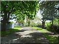
Lane round Tamworth Farm Allotments
This lane runs in a semi-circle around Tamworth Farm Allotments, to and from London Road, Mitcham. The allotments are to the left here whereas to the right are what appear to be former allotments which are now very overgrown and attract some rubbish dumping. There seems to be no vehicle access to the lane.
Image: © Marathon
Taken: 16 May 2012
0.13 miles
2
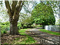
Lane behind Tamworth Farm Allotments
This lane runs in a semi-circle around Tamworth Farm Allotments, to and from London Road, Mitcham. The allotments are to the right here whereas to the left are what appear to be former allotments which are now very overgrown and attract some rubbish dumping. There seems to be no vehicle access to the lane.
Image: © Marathon
Taken: 16 May 2012
0.13 miles
3
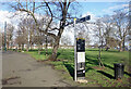
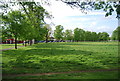
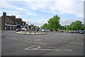
Signpost on Figges Marsh
At the southern end of a triangular piece of open space, nearly all of which can be seen in this picture.
Image: © Des Blenkinsopp
Taken: 6 Feb 2025
0.14 miles
4
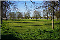
Figge's Marsh
An area of common land now adopted by Merton Council.
Image: © Bill Boaden
Taken: 30 Apr 2016
0.14 miles
7
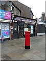
Second Hand shop on London Road, Mitcham
Showing position of Postbox No. CR4 8.
See Image] for postbox.
Image: © JThomas
Taken: 25 Jul 2022
0.15 miles
8
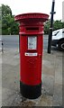
Victorian postbox on London Road, Mitcham
Postbox No. CR4 8.
See Image] for context.
Image: © JThomas
Taken: 25 Jul 2022
0.15 miles
10
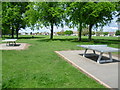
Table tennis on Figge's Marsh
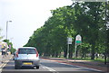
Despite suggestions that this was formerly Pigs’ Marsh, Figge's Marsh was in fact named after William Figge, who held the land from 1357. It was common land and had been vested in the Board of Mitcham Common Conservators since 1891. It was taken over by Mitcham Urban District Council under a private Act in 1923. The area was mostly built up in the mid-20th century, much of it with council housing. Figge's Marsh was formerly home to Tooting Graveney FC (which is now Tooting and Mitcham FC) and Mitcham Rugby Club. The houses on the far side are in Manship Road. Figge's Marsh is completely flat and very largely featureless, so the avenue of trees and the table tennis tables help to provide some interest for a photograph.
Image: © Marathon
Taken: 16 May 2012
0.16 miles