IMAGES TAKEN NEAR TO
Church Place, MITCHAM, CR4 3HY
Introduction
This page details the photographs taken nearby to Church Place, CR4 3HY by members of the Geograph project.
The Geograph project started in 2005 with the aim of publishing, organising and preserving representative images for every square kilometre of Great Britain, Ireland and the Isle of Man.

There are currently over 7.5m images from over14,400 individuals and you can help contribute to the project by visiting https://www.geograph.org.uk
Image Map
Images are licensed for reuse under creativecommons.org/licenses/by-sa/2.0
Notes
- Clicking on the map will re-center to the selected point.
- The higher the marker number, the further away the image location is from the centre of the postcode.
Image Listing (92 Images Found)
Images are licensed for reuse under creativecommons.org/licenses/by-sa/2.0
Image
Details
Distance
1
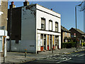
Formerly The Bull
It looks as if this closed as a pub some time ago.
Image: © Robin Webster
Taken: 1 Apr 2012
0.02 miles

3
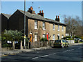
Older houses, Mitcham
16 to 18 (evens) Church Road.
Image: © Robin Webster
Taken: 1 Apr 2012
0.05 miles
4
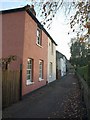
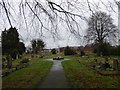
Love Lane, Mitcham
Here the lane is now merely a footpath connecting the roadway of Love Lane to Church Road, ahead. Cottages face the churchyard of Image
Image: © Derek Harper
Taken: 16 Nov 2010
0.09 miles
6
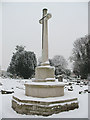
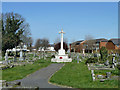
Mitcham churchyard: war memorial
The World War 1 memorial (reference 12316 in the UK National Inventory www.ukniwm.org.uk ) in the parish churchyard. It is of an apparently identical design to the one in nearby Wimbledon Cemetery Image
The inscription (taken from the UKNIWM entry) reads: "THIS CROSS OF SACRIFICE IS ONE IN DESIGN AND INTENTION WITH THOSE WHICH HAVE BEEN SET UP IN FRANCE AND BELGIUM AND OTHER PLACES THROUGHOUT THE WORLD WHERE OUR DEAD OF THE GREAT WAR ARE LAID TO REST./ THEIR NAME LIVETH FOR EVERMORE.
"
Image: © Stephen Craven
Taken: 13 Jan 2010
0.11 miles
7
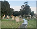
The churchyard, Mitcham parish church
The eastern end of the churchyard, looking towards Love Lane. The churchyard is vast, and its size must have to do with the fact that the Wandle valley was the site of much early industrialisation - with the old Surrey Iron railway passing nearby.
Photo taken on the afternoon of a gloomy, chilly day in December - the frost on the path had persisted all day.
Image: © Stefan Czapski
Taken: 2 Dec 2012
0.11 miles
8
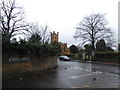
Junction of Vicarage Gardens and Church Road
Image: © Basher Eyre
Taken: 3 Feb 2018
0.11 miles
10
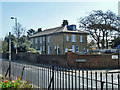
Former vicarage, Mitcham
Across Church Road from the church. Now flats.
Image: © Robin Webster
Taken: 1 Apr 2012
0.12 miles