IMAGES TAKEN NEAR TO
Church Road, MITCHAM, CR4 3GJ
Introduction
This page details the photographs taken nearby to Church Road, CR4 3GJ by members of the Geograph project.
The Geograph project started in 2005 with the aim of publishing, organising and preserving representative images for every square kilometre of Great Britain, Ireland and the Isle of Man.

There are currently over 7.5m images from over14,400 individuals and you can help contribute to the project by visiting https://www.geograph.org.uk
Image Map
Images are licensed for reuse under creativecommons.org/licenses/by-sa/2.0
Notes
- Clicking on the map will re-center to the selected point.
- The higher the marker number, the further away the image location is from the centre of the postcode.
Image Listing (12 Images Found)
Images are licensed for reuse under creativecommons.org/licenses/by-sa/2.0
Image
Details
Distance
1
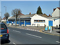
Industrial building on Church Road, Mitcham
This is divided up into several small units, just about all anonymous.
Image: © Robin Webster
Taken: 1 Apr 2012
0.01 miles
2
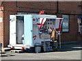
Sea food stall, Mitcham
Open Thursdays to Sundays.
Image: © Robin Webster
Taken: 1 Apr 2012
0.05 miles
3
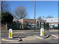
Haslemere Primary School.
Church Road entrance.
Image: © Alex McGregor
Taken: 8 Mar 2010
0.06 miles
4
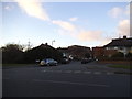
Yarborough Road at the junction of Liberty Avenue
Image: © David Howard
Taken: 1 Dec 2013
0.07 miles
5
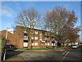
Flats near Mitcham
A low-rise block of flats near Mitcham, in the suburbs of south London.
This image was taken in early January. The trees were bare, the sun was low in the sky and the shadows were long.
Image: © Malc McDonald
Taken: 4 Jan 2020
0.07 miles
6
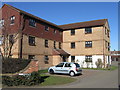
Lime Court, Mitcham
Flats viewed from Lewis Road.
Image: © Alex McGregor
Taken: 8 Mar 2010
0.07 miles
7
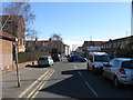
Lewis Road, Mitcham
Road viewed from Church Road.
Image: © Alex McGregor
Taken: 8 Mar 2010
0.11 miles
8
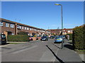
Sycamore Gardens, Mitcham
A quiet cul-de-sac.
Image: © Alex McGregor
Taken: 8 Mar 2010
0.13 miles

10
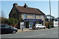
The Wheatsheaf
Not a pub but 'Your local convenience store'. Although not looking much like an ex-pub, reference to old maps shows that there was indeed a pub here, in the same block as houses to the left. These have now been demolished. Presumably the pub was called The Wheatsheaf.
Image: © Robin Webster
Taken: 1 Apr 2012
0.19 miles