IMAGES TAKEN NEAR TO
St. Barnabas Road, MITCHAM, CR4 2DW
Introduction
This page details the photographs taken nearby to St. Barnabas Road, CR4 2DW by members of the Geograph project.
The Geograph project started in 2005 with the aim of publishing, organising and preserving representative images for every square kilometre of Great Britain, Ireland and the Isle of Man.

There are currently over 7.5m images from over14,400 individuals and you can help contribute to the project by visiting https://www.geograph.org.uk
Image Map
Images are licensed for reuse under creativecommons.org/licenses/by-sa/2.0
Notes
- Clicking on the map will re-center to the selected point.
- The higher the marker number, the further away the image location is from the centre of the postcode.
Image Listing (67 Images Found)
Images are licensed for reuse under creativecommons.org/licenses/by-sa/2.0
Image
Details
Distance
1
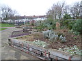
Edenvale Open Space
This small recreation ground is accessible from Woodland Way, where it is behind the North East Mitcham Community Centre, and from Edenvale Road. It packs quite a lot into its area, including a wildlife area, a playground and this raised garden. The houses in the distance are in Edenvale Road. See http://www.merton.gov.uk/environment/openspaces/parks/parks_in_the_mitcham_area/edenvale_open_space.htm for more information.
Image: © Marathon
Taken: 21 Jan 2015
0.09 miles
2
Landscaping in Edenvale Open Space
This small recreation ground is accessible from Woodland Way, where it is behind the North East Mitcham Community Centre, and from Edenvale Road. It packs quite a lot into its area, including a wildlife area, a playground and a raised garden. The houses in the distance are in Edenvale Road. See http://www.merton.gov.uk/environment/openspaces/parks/parks_in_the_mitcham_area/edenvale_open_space.htm for more information.
Image: © Marathon
Taken: 21 Jan 2015
0.09 miles
3
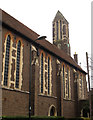
St Barnabas church, Mitcham: bell tower
The church has a small bell and clock tower at the east end.
John Salmon has taken a lot of other detailed photos of the church: http://www.geograph.org.uk/search.php?i=40040829
Image: © Stephen Craven
Taken: 26 Feb 2013
0.09 miles
4
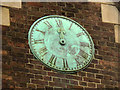
St Barnabas church, Mitcham: clock face
There is a single, small clock face on the southern side of the bell tower Image As of 2013 the clock was non-functional but there was talk of restoring it.
John Salmon has taken a lot of other detailed photos of the church: http://www.geograph.org.uk/search.php?i=40040829
Image: © Stephen Craven
Taken: 26 Feb 2013
0.09 miles
5
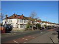
Streatham Road, near Mitcham
Streatham Road forms part of the short A216 road in the south London suburbs.
Image: © Malc McDonald
Taken: 4 Jan 2020
0.09 miles
6
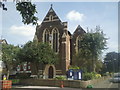
St Barnabas Church, Mitcham
The present church was completed in 1914 in the Gothic style. The frontage is in Thirsk Road and this photograph is taken from Gorringe Park Avenue.
Image: © Marathon
Taken: 1 Sep 2010
0.09 miles
7
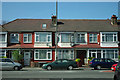
Houses on Streatham Road
Opposite the end of Melrose Avenue.
Image: © Robin Webster
Taken: 1 Apr 2012
0.10 miles
8
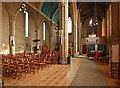
St Barnabas, Gorringe Park Avenue, Mitcham - South aisle
Image: © John Salmon
Taken: 7 Feb 2012
0.10 miles
9
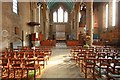
St Barnabas, Gorringe Park Avenue, Mitcham - East end
Image: © John Salmon
Taken: 7 Feb 2012
0.10 miles
10
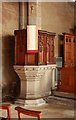
St Barnabas, Gorringe Park Avenue, Mitcham - Pulpit
Image: © John Salmon
Taken: 7 Feb 2012
0.10 miles