IMAGES TAKEN NEAR TO
Lincoln Road, MITCHAM, CR4 1QQ
Introduction
This page details the photographs taken nearby to Lincoln Road, CR4 1QQ by members of the Geograph project.
The Geograph project started in 2005 with the aim of publishing, organising and preserving representative images for every square kilometre of Great Britain, Ireland and the Isle of Man.

There are currently over 7.5m images from over14,400 individuals and you can help contribute to the project by visiting https://www.geograph.org.uk
Image Map
Images are licensed for reuse under creativecommons.org/licenses/by-sa/2.0
Notes
- Clicking on the map will re-center to the selected point.
- The higher the marker number, the further away the image location is from the centre of the postcode.
Image Listing (21 Images Found)
Images are licensed for reuse under creativecommons.org/licenses/by-sa/2.0
Image
Details
Distance
1
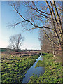
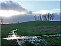
Waterlogged path, Mitcham Common
Due to prolonged recent rain.
Image: © Stephen Richards
Taken: 2 Jan 2014
0.12 miles
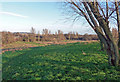
2
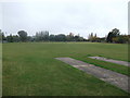
Mayfield Recreational Ground
Large sports ground at the end of an access road from Mayfield Road, leading to a large plot of allotments and the sports field.
Image: © David Anstiss
Taken: 30 Oct 2011
0.13 miles
3
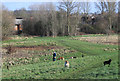
Dogs on the Common
The northern edge of Mitcham Common. A man out for a walk with seven dogs. These three came charging towards me but stopped in their tracks when he shouted. I was impressed, and not a little relieved.
Image: © Des Blenkinsopp
Taken: 11 Feb 2020
0.13 miles
4
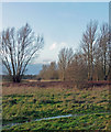
Mitcham Common (3)
The path in front has been saturated by prolonged recent rain.
Image: © Stephen Richards
Taken: 2 Jan 2014
0.14 miles
5
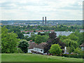
View south from Pollards Hill
Looking towards the chimneys of the former Croydon power station, a site used by the Ikea store.
Image: © Robin Webster
Taken: 1 Jul 2011
0.14 miles
6
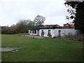
Sports Pavilion, Mayfield Recreational Ground
This neglected sports pavilion is at the end of Mayfield Recreational Ground access road.
Image: © David Anstiss
Taken: 30 Oct 2011
0.14 miles
7
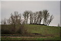
Mitcham Common
The background hill is man-made, with household refuse being covered by earth. The trees are now well established and the casual observer would have no idea of the history.
Back in the 1960s, this area was completely flat and the circus would perform here. Although the funfair was usually held at the western end of Mitcham Common, there were occasions on which it was held here, the eastern edge of the common.
Image: © Peter Trimming
Taken: 24 Jan 2023
0.17 miles
8
Mitcham Common (4)
At about 3pm, the sun was shutting up shop for the day having been the subject of a hostile takeover by clouds.
The ground has been saturated by prolonged recent rain.
Image: © Stephen Richards
Taken: 2 Jan 2014
0.18 miles
9
Mitcham Common (2)
Faintly visible on the far left is the TV mast at Crystal Palace.
Image: © Stephen Richards
Taken: 2 Jan 2014
0.18 miles
10
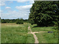
Public footpath, Mitcham Common
This runs along the edge of the common, separated from a residential area to the right by a tree belt, a ditch and a fence, with occasional access points. One is just ahead.
Image: © Robin Webster
Taken: 1 Jul 2011
0.20 miles