IMAGES TAKEN NEAR TO
North Down, SOUTH CROYDON, CR2 9PB
Introduction
This page details the photographs taken nearby to North Down, CR2 9PB by members of the Geograph project.
The Geograph project started in 2005 with the aim of publishing, organising and preserving representative images for every square kilometre of Great Britain, Ireland and the Isle of Man.

There are currently over 7.5m images from over14,400 individuals and you can help contribute to the project by visiting https://www.geograph.org.uk
Image Map
Images are licensed for reuse under creativecommons.org/licenses/by-sa/2.0
Notes
- Clicking on the map will re-center to the selected point.
- The higher the marker number, the further away the image location is from the centre of the postcode.
Image Listing (8 Images Found)
Images are licensed for reuse under creativecommons.org/licenses/by-sa/2.0
Image
Details
Distance
1
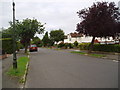
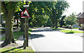
Tranquil suburbia in Glebe Hyrst, Sanderstead, Surrey
You will need a minimum of half a million pounds if you are considering buying a house here!
Image: © Dr Neil Clifton
Taken: 20 Sep 2005
0.09 miles
2
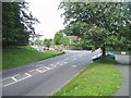
Purley Downs Road junction
Purley Downs Road enters Sanderstead Road here. Usually a busy junction.
Image: © Nigel Freeman
Taken: 20 Sep 2005
0.14 miles
3
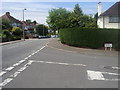
Brian Avenue, Sanderstead
I have no idea who Brian is or was.
Image: © David Howard
Taken: 29 Oct 2012
0.15 miles
4
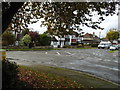
Briton Crescent
Junction of Briton Crescent with Purley Downs Road
Image: © Shaun Ferguson
Taken: 26 Jun 2012
0.16 miles
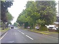
5
Rectory Park - Steep Hill 12%
Rectory Park, Sanderstead. 12% steep hill down sign.
Image: © Adam Morse
Taken: 11 Jun 2009
0.16 miles
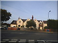
7
Rectory Park
The view along the A2022 in Sanderstead, Croydon.
Image: © Gordon Griffiths
Taken: 25 May 2018
0.20 miles
8
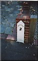
Old Milepost by the B269, Selsdon and Sanderstead parish
Cast iron post by the B269, in parish of SELSDON AND SANDERSTEAD (CROYDON District), Sanderstead Hill, by No.36, half mile North of the junction with the A2022, back of pavement against brick gate pillar, on West side of road. Croydon gable iron plate, erected by the Limpsfield turnpike trust in the 19th century.
Inscription reads:-
CROYDON
2
(?)
IRON
FOUNDRY
Milestone Society National ID: SY_CYLF02.
Image: © JS Payne
Taken: 1 Oct 2007
0.23 miles