IMAGES TAKEN NEAR TO
Hyde Road, SOUTH CROYDON, CR2 9NS
Introduction
This page details the photographs taken nearby to Hyde Road, CR2 9NS by members of the Geograph project.
The Geograph project started in 2005 with the aim of publishing, organising and preserving representative images for every square kilometre of Great Britain, Ireland and the Isle of Man.

There are currently over 7.5m images from over14,400 individuals and you can help contribute to the project by visiting https://www.geograph.org.uk
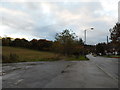
Image Map
Images are licensed for reuse under creativecommons.org/licenses/by-sa/2.0
Notes
- Clicking on the map will re-center to the selected point.
- The higher the marker number, the further away the image location is from the centre of the postcode.
Image Listing (25 Images Found)
Images are licensed for reuse under creativecommons.org/licenses/by-sa/2.0
Image
Details
Distance
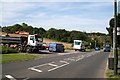
3
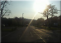
Mitchley Avenue Sanderstead
Heading west into the sun
Image: © David Howard
Taken: 18 Apr 2011
0.06 miles
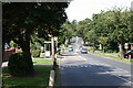
5
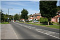
Mitchley Avenue, Sanderstead (2)
Looking westward from No 99 (with pink garage door) and descending. This is the north side of the A2022. The road descends, then ascends again before finally leading via steep descents to Purley.
Image: © Dr Neil Clifton
Taken: 3 Aug 2007
0.08 miles
6
Mitchley Avenue, Sanderstead (3)
Looking west. The south side of the A2022 is unbuilt at this point so a small car park has been constructed, but it soon becomes full.
Image: © Dr Neil Clifton
Taken: 3 Aug 2007
0.08 miles
7
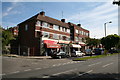
Mitchley Avenue, Sanderstead (4)
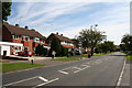
Looking east. This small parade of shops lies just west of No 85 on the north side. From the near end, they are: a newsagents and general shop: a glass and mirror shop: a small cafe: and then, of course, all the rest of the frontage is taken up by an estate agent. The road leading off just before the shops is Copthorne Rise.
Image: © Dr Neil Clifton
Taken: 3 Aug 2007
0.10 miles
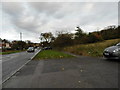
8
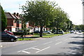
Mitchley Avenue, Sanderstead (7)
Looking eastwards along this road, which is the A2022, the first house visible on the north side is No 89 and the odd numbers ascend from there. There are no buildings on the south side, so these houses have a very pleasant open outlook.
Image: © Dr Neil Clifton
Taken: 3 Aug 2007
0.10 miles
9
Mitchley Avenue, Sanderstead (1)
Looking eastwards from No. 103 and ascending. The road is the A2022 and leads to Selsdon and Addington.
Image: © Dr Neil Clifton
Taken: 3 Aug 2007
0.11 miles
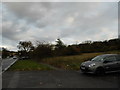
10
Mitchley Avenue, Sanderstead (6)
Looking westward from the junction with Copthorne Rise, Mitchley Avenue (the A2022) dips and then rises again to where it becomes Downs Court Road and starts the steep descent to Purley.
Image: © Dr Neil Clifton
Taken: 3 Aug 2007
0.11 miles