IMAGES TAKEN NEAR TO
Croham Valley Road, SOUTH CROYDON, CR2 7NA
Introduction
This page details the photographs taken nearby to Croham Valley Road, CR2 7NA by members of the Geograph project.
The Geograph project started in 2005 with the aim of publishing, organising and preserving representative images for every square kilometre of Great Britain, Ireland and the Isle of Man.

There are currently over 7.5m images from over14,400 individuals and you can help contribute to the project by visiting https://www.geograph.org.uk
Image Map
Images are licensed for reuse under creativecommons.org/licenses/by-sa/2.0
Notes
- Clicking on the map will re-center to the selected point.
- The higher the marker number, the further away the image location is from the centre of the postcode.
Image Listing (48 Images Found)
Images are licensed for reuse under creativecommons.org/licenses/by-sa/2.0
Image
Details
Distance
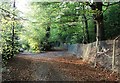
1
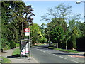
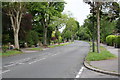
Croham Valley Road
Croham Valley Road, looking eastwards.
Image: © Malc McDonald
Taken: 22 May 2010
0.02 miles
2
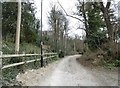
Croydon, Ballards Farm Road
Bridleway and access road, from Croham Valley Road to Coombe Lane.
Image: © Mike Faherty
Taken: 19 Mar 2016
0.06 miles
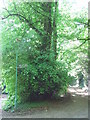
3
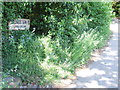
Ballards Farm Road
Sign for Ballards Farm Road, public bridleway.
Image: © Malc McDonald
Taken: 22 May 2010
0.07 miles
5
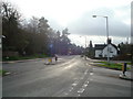
Junction on Ballards Farm Road
Ballards Farm Road leads from Ballards Way left down towards Croham road.
Conduit Lane heads right, around Coombe Wood (on the right) towards Coombe Lane.
The Vanguard Way (long distance path) also heads right as well towards Coombe Lane.
Image: © David Anstiss
Taken: 23 Oct 2011
0.07 miles
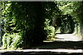
6
Vanguard Way
The Vanguard Way is a 66-mile footpath from Croydon to Newhaven, crossing the North Downs, The Weald and the South Downs. This photo shows the path as it is joined by another short bridleway, close to Croham Valley Road.
Image: © Malc McDonald
Taken: 22 May 2010
0.08 miles
7
Ballards Farm Road
Running along the southern edge of the Coombe Wood estate.
Image: © Peter Trimming
Taken: 29 Jun 2018
0.08 miles
8
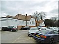
Sanderstead, clubhouse
Home to Croham Hurst Golf Club, on the northern edge of the Hurst: http://www.chgc.co.uk/
Image: © Mike Faherty
Taken: 19 Mar 2016
0.08 miles
9
South Croydon: Croham Valley Road
Looking northwest from the end of Ballards Rise, the very rare sight of a completely car-free road - no doubt the Queen showed good sense in declaring today as a second Bank Holiday.
Image: © Dr Neil Clifton
Taken: 5 Jun 2012
0.09 miles
10
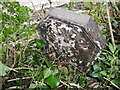
Old Boundary Marker by Croham Hurst Golf Club road, Croydon
Parish Boundary Marker by the private road, in parish of Croydon (Croydon District), Croham Hurst Golf Club, entrance road in undergrowth facing woodland.
Inscription reads:- : CROYDON / 1920 / PARISH :
Surveyed
Milestone Society National ID: SY_CROY06pb
Image: © Milestone Society
Taken: Unknown
0.09 miles