IMAGES TAKEN NEAR TO
Victoria Avenue, SOUTH CROYDON, CR2 0QP
Introduction
This page details the photographs taken nearby to Victoria Avenue, CR2 0QP by members of the Geograph project.
The Geograph project started in 2005 with the aim of publishing, organising and preserving representative images for every square kilometre of Great Britain, Ireland and the Isle of Man.

There are currently over 7.5m images from over14,400 individuals and you can help contribute to the project by visiting https://www.geograph.org.uk
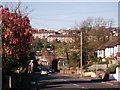
Image Map (Loading...)


Getting Data...Please wait
Leaflet Map data © OpenStreetMap
Images are licensed for reuse under creativecommons.org/licenses/by-sa/2.0
Notes
- Clicking on the map will re-center to the selected point.
- The higher the marker number, the further away the image location is from the centre of the postcode.
Image Listing (41 Images Found)
Images are licensed for reuse under creativecommons.org/licenses/by-sa/2.0
Image
Details
Distance
1
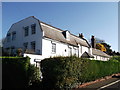
Purley Bury, Lexington Court
Grade II listed house on Lexington Court.
John Horne Tooke, politician and writer, and author of "The Diversions of Purley", lived here.
See http://www.britishlistedbuildings.co.uk/en-201220-purley-bury-croydon for more details about the house.
Image: © David Anstiss
Taken: 13 Nov 2011
0.12 miles
2
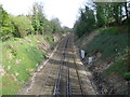
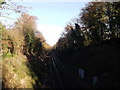
View from Purley Downs Road of the railway line
The South Eastern Railway and the London, Brighton & South Coast Railway opened their line between Croydon and East Grinstead on 10 March 1884. This is the view from Purley Downs Road and looks in the direction of Sanderstead station.
Image: © Marathon
Taken: 14 Apr 2012
0.13 miles
3
View of the railway line from Purley Downs Road
The South Eastern Railway and the London, Brighton & South Coast Railway opened their line between Croydon and East Grinstead on 10 March 1884. This is the view from Purley Downs Road and looks in the direction of Sanderstead station.
Image: © Marathon
Taken: 14 Apr 2012
0.13 miles
4
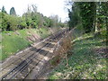
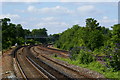
Purley
The railway line from East Grinstead, looking in the direction of East Croydon. Seen from Purley Downs Road.
Image: © Peter Trimming
Taken: 18 May 2020
0.13 miles
5
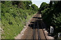
Railway line to Sanderstead
As seen from Image
This line leads from Oxted (via Woldingham, Warlingham and Riddlesdown), then it heads to Sanderstead and onwards to South Croydon.
Image: © David Anstiss
Taken: 13 Nov 2011
0.13 miles
6
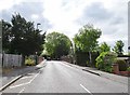
Purley Downs Road
The view up Purley Downs Road at the railway bridge, in Purley.
Image: © Gordon Griffiths
Taken: 6 May 2019
0.14 miles
7
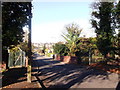
Purley Downs Railway bridge
This road leads down from Sanderstead towards Purley. It passes over the railway between Sanderstead and Riddlesdown.
Image: © David Anstiss
Taken: 13 Nov 2011
0.15 miles
8
View From Purley Oaks Station
Looking towards the south-west, in the direction of Purley station. The 'fast' lines are seen to the right of picture, whilst the 'slow' lines, to the left of picture, serve platforms 3 and 4.
Image: © Peter Trimming
Taken: 14 Jul 2011
0.16 miles
9
Railway bridge on Purley Downs Road
This road leads down from Sanderstead towards Purley.
The railway bridge carries the line between Purley Oaks and Purley.
Image: © David Anstiss
Taken: 13 Nov 2011
0.16 miles
10
Purley Oaks recycling depot
When open, this depot is very busy. Only residents of the Borough of Croydon are admitted free of charge: others must pay a £5 fee to dump rubbish here.
Image: © Dr Neil Clifton
Taken: 23 Aug 2008
0.17 miles