IMAGES TAKEN NEAR TO
Sydenham Road, CROYDON, CR0 9BL
Introduction
This page details the photographs taken nearby to Sydenham Road, CR0 9BL by members of the Geograph project.
The Geograph project started in 2005 with the aim of publishing, organising and preserving representative images for every square kilometre of Great Britain, Ireland and the Isle of Man.

There are currently over 7.5m images from over14,400 individuals and you can help contribute to the project by visiting https://www.geograph.org.uk
Image Map
Images are licensed for reuse under creativecommons.org/licenses/by-sa/2.0
Notes
- Clicking on the map will re-center to the selected point.
- The higher the marker number, the further away the image location is from the centre of the postcode.
Image Listing (555 Images Found)
Images are licensed for reuse under creativecommons.org/licenses/by-sa/2.0
Image
Details
Distance
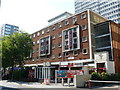
1
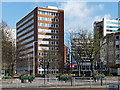
Canterbury House, Sydenham Road
By T.P. Bennett and Sons, 1963-65.
Between the 1950s and the 1970s Croydon experienced a burst of commercial development unparalleled anywhere else in the country. The impetus was provided by the Croydon Corporation Act of 1956 which gave Croydon Council powers to develop land in the borough. A combination of improved roads, government incentives to relocate from, and Croydon's proximity to, central London, and lower rents attracted employers in their droves. By 1970 about six million square feet of office space had been provided in central Croydon. Development has continued since, but at a much slower rate. From a distance the skyline is impressive (the nearest this country comes to Manhattan), but the problem is that few of the buildings are of architectural merit.
Image: © Stephen Richards
Taken: Unknown
0.00 miles
2
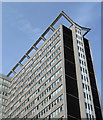
Detail of Lunar House, Wellesley Road (2)
I can think of no functional reasons for the projecting frame at the top - perhaps it represents an unexpected dash of whimsy.
Wider view: Image
Image: © Stephen Richards
Taken: 2 Mar 2019
0.04 miles
3
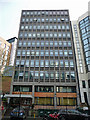
Cygnet House, Sydenham Road
One of Croydon's more modest 1960s (former) office blocks.
It is now flats. A remarkable number of Croydon's office blocks are either being converted, or have been converted into flats in recent years. Under permitted development rights, such conversions do not require planning permission. What's the betting there'll be a serious shortage of office space in a few years?
Image: © Stephen Richards
Taken: 2 Mar 2019
0.04 miles
4
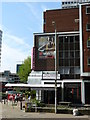
Fairfield Hotel, Croydon
On the junction of Lansdowne Road and Wellesley Road.
Image: © Peter Trimming
Taken: 24 Apr 2009
0.04 miles
5
Fairfield Hotel, Croydon
Once the largest hotel in Central Croydon, there are now at least three which are much larger.
Image: © Peter Trimming
Taken: 24 Apr 2009
0.04 miles
6
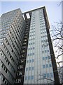
Croydon: Lunar House, detail
Lunar House, one of the Wellesley Road office blocks that dates from the council's late 1960s decision to attract commercial office space (the name nods to the late 60s moon landings, as does the adjacent Apollo House), is a base for the Home Office's visa operations.
Image: © Christopher Hilton
Taken: 28 Jan 2014
0.05 miles
7
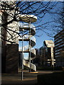
Fire escape, Lunar House, Croydon
On the southeast side of Image, seen from beside Wellesley Road.
Image: © Derek Harper
Taken: 9 Dec 2011
0.06 miles
8
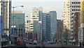
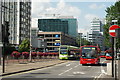
Street Scene, Wellesley Road, Croydon
Wellesley Road, in all its glory. Photograph taken from above the underpass.
Image: © Peter Trimming
Taken: 8 Jan 2009
0.06 miles
9
Wellesley Road, Croydon
Mid summer, and the floral displays are in full bloom along this stretch of Wellesley Road. The TfL colours of the tram make a nice contrast against the colours of the flowers, and all the buses.
Image: © Peter Trimming
Taken: 13 Aug 2009
0.06 miles
10
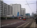
Croydon: Wellesley Road
Looking north from the tram stop.
Image: © Dr Neil Clifton
Taken: 4 Jan 2011
0.06 miles